Weather Alerts for Arizona
1. Red Flag Warning for: Pima-South Central Pinal-Tohono Oodham Nation; Eastern Pima-Southeastern Pinal-Santa Cruz-Western Cochise; Southern Graham-Central and Eastern Cochise-Southern Greenlee-Lower Elevations of the San Carlos Apache Nation in Graham County
2. Wind Advisory for: Chuska Mountains and Defiance Plateau; Black Mesa Area; Northeast Plateaus and Mesas South of Hwy 264
3. Wind Advisory for: Kaibab Plateau; Grand Canyon Country; Coconino Plateau
4. Wind Advisory for: Little Colorado River Valley in Coconino County; Little Colorado River Valley in Navajo County; Little Colorado River Valley in Apache County; Western Mogollon Rim; Eastern Mogollon Rim
5. Wind Advisory for: Northeast Plateaus and Mesas Hwy 264 Northward
6. Wind Advisory for: Northwest Plateau; Lake Mead National Recreation Area; Northeast Clark County; Lake Mead National Recreation Area; Southern Clark County
7. Wind Advisory for: Upper San Pedro River Valley including Sierra Vista/Benson; Eastern Cochise County Below 5000 Feet including Douglas/Willcox; Upper Gila River and Aravaipa Valleys including Clifton/Safford; White Mountains of Graham and Greenlee Counties including Hannagan Meadow; Galiuro and Pinaleno Mountains including Mount Graham; Chiricahua Mountains including Chiricahua National Monument; Dragoon/Mule/Huachuca and Santa Rita Mountains including Bisbee/Canelo Hills/Madera Canyon
8. Wind Advisory for: White Mountains
Want more detail? Get the Complete 7 Day and Night Detailed Forecast!
Current U.S. National Radar--Current
The Current National Weather Radar is shown below with a UTC Time (subtract 5 hours from UTC to get Eastern Time).

National Weather Forecast--Current
The Current National Weather Forecast and National Weather Map are shown below.

National Weather Forecast for Tomorrow
Tomorrow National Weather Forecast and Tomorrow National Weather Map are show below.

North America Water Vapor (Moisture)
This map shows recent moisture content over North America. Bright and colored areas show high moisture (ie, clouds); brown indicates very little moisture present; black indicates no moisture.

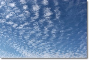
Weather Topic: What are Cirrocumulus Clouds?
Home - Education - Cloud Types - Cirrocumulus Clouds
 Next Topic: Cirrostratus Clouds
Cirrocumulus clouds form at high altitudes (usually around 5 km)
and have distinguishing characteristics displayed in a fine layer of
small cloud patches. These small cloud patches are sometimes referred to as
"cloudlets" in relation to the whole cloud formation.
Cirrocumulus clouds are formed from ice crystals and water droplets. Often, the
water droplets in the cloud freeze into ice crystals and the cloud becomes a
cirrostratus cloud. Because of this common occurrence, cirrocumulus cloud
formations generally pass rapidly.
Next Topic: Cirrostratus Clouds
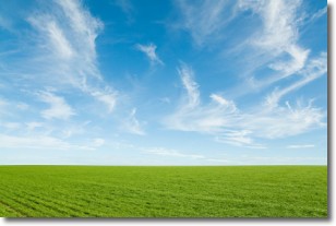
Weather Topic: What are Cirrus Clouds?
Home - Education - Cloud Types - Cirrus Clouds
 Next Topic: Condensation
Cirrus clouds are high-level clouds that occur above 20,000 feet
and are composed mainly of ice crystals.
They are thin and wispy in appearance.
What do they indicate?
They are often the first sign of an approaching storm.
Next Topic: Condensation
Current conditions powered by WeatherAPI.com


