Weather Alert in California
Winter Storm Warning issued March 30 at 12:38PM PDT until April 1 at 5:00PM PDT by NWS Medford OR
AREAS AFFECTED: South Central Siskiyou County
DESCRIPTION: * WHAT...For the Winter Storm Warning, heavy snow expected. Total snow accumulations between 1 and 3 feet possible. Winds gusting as high as 50 mph. For the Winter Weather Advisory, snow expected. Total snow accumulations between 2 and 8 inches possible, with up to 12 inches of snow possible at Snowmans Summit. * WHERE...For the Winter Storm Warning, portions of Siskiyou County above 4500 feet, including the Mount Shasta highlands, Medicine Lake, and the Klamath, Salmon, and Trinity mountains, as well as Etna Summit and Scott Mountain Summit. For the Winter Weather Advisory, portions of I-5 south of Weed and Highway 89, including Mount Shasta City, Dunsmuir, and McCloud. * WHEN...For the Winter Storm Warning, from 11 PM this evening to 5 PM PDT Tuesday. For the Winter Weather Advisory, from 11 PM Monday to 5 PM PDT Tuesday. * IMPACTS...Travel could be very difficult to impossible. The hazardous conditions could impact the Monday morning and evening commutes. Strong winds could cause tree damage.
INSTRUCTION: If you must travel, keep an extra flashlight, food, and water in your vehicle in case of an emergency. Call 511 or visit quickmap.dot.ca.gov for road information. Slow down and use caution while traveling. Call 511 or visit quickmap.dot.ca.gov for road information.
Want more detail? Get the Complete 7 Day and Night Detailed Forecast!
Current U.S. National Radar--Current
The Current National Weather Radar is shown below with a UTC Time (subtract 5 hours from UTC to get Eastern Time).

National Weather Forecast--Current
The Current National Weather Forecast and National Weather Map are shown below.

National Weather Forecast for Tomorrow
Tomorrow National Weather Forecast and Tomorrow National Weather Map are show below.

North America Water Vapor (Moisture)
This map shows recent moisture content over North America. Bright and colored areas show high moisture (ie, clouds); brown indicates very little moisture present; black indicates no moisture.

Weather Topic: What is Graupel?
Home - Education - Precipitation - Graupel
 Next Topic: Hail
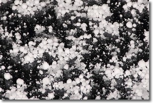
Graupel is a form of precipitation that is created by atmospheric conditions
which cause supercooled water droplets to contact snow crystals and freeze to
their surface.
Sometimes known as soft hail or snow pellets, graupel is delicate and easily
destroyed by touch. Whereas hail usually falls during severe weather, graupel
doesn't require such conditions to form, and can form in mild precipitation
similar to situations which produce snowfall.
Next Topic: Hail
Weather Topic: What are Hole Punch Clouds?
Home - Education - Cloud Types - Hole Punch Clouds
 Next Topic: Mammatus Clouds
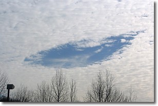
A hole punch cloud is an unusual occurrence when a disk-shaped
hole appears in a cirrostratus, cirrocumulus, or altocumulus cloud.
When part of the cloud forms ice crystals, water droplets in the surrounding area
of the cloud evaporate. The effect of this process produces a large elliptical
gap in the cloud. The hole punch cloud formation is rare, but it is not specific
to any geographic area.
Other names which have been used to describe this phenomena include fallstreak hole,
skypunch, and cloud hole.
Next Topic: Mammatus Clouds
Current conditions powered by WeatherAPI.com


