Weather Alert in Mississippi
Flood Warning issued April 3 at 9:42AM CDT by NWS Memphis TN
AREAS AFFECTED: Tate, MS; Tunica, MS
DESCRIPTION: ...The Flood Warning is extended for the following rivers in Mississippi... Coldwater River near Sarah For the Coldwater River...including Sarah...Minor flooding is forecast. * WHAT...Minor flooding is forecast. * WHERE...Coldwater River near Sarah. * WHEN...From this afternoon until further notice. * IMPACTS...At 23.0 feet, Flooding is occurring on the left bank. Mainly agricultural land is flooded. The levee system protects the right bank from flooding. * ADDITIONAL DETAILS... - At 9:00 AM CDT Thursday the stage was 15.6 feet. - Forecast...The river will rise above flood stage this afternoon to 20.5 feet just after midnight tonight. It will then rise to 23.5 feet Sunday evening. Pay close attention to subsequent forecasts as multiple days of rain will impact the crest and duration of the flooding. - Flood stage is 18.0 feet. - http://www.weather.gov/safety/flood
INSTRUCTION: Turn around, don't drown when encountering flooded roads. Most flood deaths occur in vehicles. Additional information is available at weather.gov/memphis. The next statement will be issued as needed.
Want more detail? Get the Complete 7 Day and Night Detailed Forecast!
Current U.S. National Radar--Current
The Current National Weather Radar is shown below with a UTC Time (subtract 5 hours from UTC to get Eastern Time).

National Weather Forecast--Current
The Current National Weather Forecast and National Weather Map are shown below.

National Weather Forecast for Tomorrow
Tomorrow National Weather Forecast and Tomorrow National Weather Map are show below.

North America Water Vapor (Moisture)
This map shows recent moisture content over North America. Bright and colored areas show high moisture (ie, clouds); brown indicates very little moisture present; black indicates no moisture.

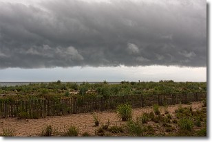
Weather Topic: What are Shelf Clouds?
Home - Education - Cloud Types - Shelf Clouds
 Next Topic: Sleet
A shelf cloud is similar to a wall cloud, but forms at the front
of a storm cloud, instead of at the rear, where wall clouds form.
A shelf cloud is caused by a series of events set into motion by the advancing
storm; first, cool air settles along the ground where precipitation has just fallen.
As the cool air is brought in, the warmer air is displaced, and rises above it,
because it is less dense. When the warmer air reaches the bottom of the storm cloud,
it begins to cool again, and the resulting condensation is a visible shelf cloud.
Next Topic: Sleet
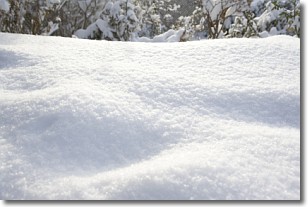
Weather Topic: What is Snow?
Home - Education - Precipitation - Snow
 Next Topic: Stratocumulus Clouds
Snow is precipitation taking the form of ice crystals. Each ice crystal, or snowflake,
has unique characteristics, but all of them grow in a hexagonal structure.
Snowfall can last for sustained periods of time and result in significant buildup
of snow on the ground.
On the earth's surface, snow starts out light and powdery, but as it begins to melt
it tends to become more granular, producing small bits of ice which have the consistency of
sand. After several cycles of melting and freezing, snow can become very dense
and ice-like, commonly known as snow pack.
Next Topic: Stratocumulus Clouds
Current conditions powered by WeatherAPI.com


