Weather Alert in New York
Air Quality Alert issued April 23 at 1:28PM EDT by NWS Upton NY
AREAS AFFECTED: Rockland; Northern Westchester; Southern Westchester; New York (Manhattan); Bronx; Richmond (Staten Is.); Kings (Brooklyn); Northwest Suffolk; Northeast Suffolk; Southwest Suffolk; Southeast Suffolk; Northern Queens; Northern Nassau; Southern Queens; Southern Nassau
DESCRIPTION: The New York State Department of Environmental Conservation has issued an Air Quality Health Advisory for the following counties: New York, Bronx, Kings, Queens, Richmond, Nassau, Suffolk, Westchester, Rockland. from midnight tonight to midnight EDT Thursday night. Air quality levels in outdoor air are predicted to be greater than an Air Quality Index value of 100 for the pollutant of Fine Particulates. The Air Quality Index, or AQI, was created as an easy way to correlate levels of different pollutants to one scale. The higher the AQI value, the greater the health concern. When pollution levels are elevated, the New York State Department of Health recommends that individuals consider limiting strenuous outdoor physical activity to reduce the risk of adverse health effects. People who may be especially sensitive to the effects of elevated levels of pollutants include the very young, and those with preexisting respiratory problems such as asthma or heart disease. Those with symptoms should consider consulting their personal physician. A toll free air quality hotline has been established so New York residents can stay informed on the air quality situation. The toll free number is 1 800 5 3 5, 1 3 4 5.
INSTRUCTION: N/A
Want more detail? Get the Complete 7 Day and Night Detailed Forecast!
Current U.S. National Radar--Current
The Current National Weather Radar is shown below with a UTC Time (subtract 5 hours from UTC to get Eastern Time).

National Weather Forecast--Current
The Current National Weather Forecast and National Weather Map are shown below.

National Weather Forecast for Tomorrow
Tomorrow National Weather Forecast and Tomorrow National Weather Map are show below.

North America Water Vapor (Moisture)
This map shows recent moisture content over North America. Bright and colored areas show high moisture (ie, clouds); brown indicates very little moisture present; black indicates no moisture.

Weather Topic: What is Sleet?
Home - Education - Precipitation - Sleet
 Next Topic: Snow
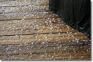
Sleet is a form of precipitation in which small ice pellets are the primary
components. These ice pellets are smaller and more translucent than hailstones,
and harder than graupel. Sleet is caused by specific atmospheric conditions and
therefore typically doesn't last for extended periods of time.
The condition which leads to sleet formation requires a warmer body of air to be
wedged in between two sub-freezing bodies of air. When snow falls through a warmer
layer of air it melts, and as it falls through the next sub-freezing body of air
it freezes again, forming ice pellets known as sleet. In some cases, water
droplets don't have time to freeze before reaching the surface and the result is
freezing rain.
Next Topic: Snow
Weather Topic: What are Stratocumulus Clouds?
Home - Education - Cloud Types - Stratocumulus Clouds
 Next Topic: Stratus Clouds
Stratocumulus clouds are similar to altocumulus clouds in their
fluffy appearance, but have a slightly darker shade due to their additional mass.
A good way to distinguish the two cloud types is to hold your hand out and measure
the size of an individual cloud; if it is the size of your thumb it is generally
an altocumulus cloud, if it is the size of your hand it is generally a
stratocumulus cloud.
It is uncommon for stratocumulus clouds to produce precipitation, but if they do
it is usually a light rain or snow.
Next Topic: Stratus Clouds
Current conditions powered by WeatherAPI.com


