Weather Alert in Texas
Fire Weather Watch issued March 14 at 4:33AM CDT until March 15 at 9:00PM CDT by NWS Houston/Galveston TX
AREAS AFFECTED: Walker; San Jacinto; Montgomery; Colorado; Austin; Waller; Inland Harris; Wharton; Fort Bend; Inland Jackson; Inland Matagorda; Inland Brazoria; Inland Galveston; Coastal Harris; Coastal Jackson; Coastal Matagorda; Coastal Brazoria
DESCRIPTION: ...Elevated to Critical Fire Weather Conditions Expected Today and Saturday... .Elevated to critical fire weather conditions are expected across portions of Southeast Texas. Southwest winds around 15 to 20 mph alongside relative humidity values in the upper teens to middle 20s today will lead to critical fire weather conditions primarily in the Brazos Valley, and extending northeastward towards the Piney Woods. More widespread low relative humidity values in the teens and 20s is expected on Saturday alongside gusty westerly winds. This creates a more widespread critical fire weather threat. * WINDS...West 10 to 20 mph with gusts up to 35 mph. * RELATIVE HUMIDITY...As low as 15-25 percent. * TEMPERATURES...Lower 80s. * IMPACTS...Any wildfires that start could rapidly increase in size and intensity, and move quickly.
INSTRUCTION: A Fire Weather Watch means that critical fire weather conditions are forecast to occur. Listen for later forecasts and possible Red Flag Warnings.
Want more detail? Get the Complete 7 Day and Night Detailed Forecast!
Current U.S. National Radar--Current
The Current National Weather Radar is shown below with a UTC Time (subtract 5 hours from UTC to get Eastern Time).

National Weather Forecast--Current
The Current National Weather Forecast and National Weather Map are shown below.

National Weather Forecast for Tomorrow
Tomorrow National Weather Forecast and Tomorrow National Weather Map are show below.

North America Water Vapor (Moisture)
This map shows recent moisture content over North America. Bright and colored areas show high moisture (ie, clouds); brown indicates very little moisture present; black indicates no moisture.

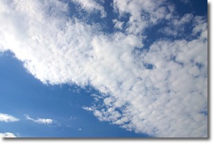
Weather Topic: What are Stratus Clouds?
Home - Education - Cloud Types - Stratus Clouds
 Next Topic: Wall Clouds
Stratus clouds are similar to altostratus clouds, but form at a
lower altitude and are identified by their fog-like appearance, lacking the
distinguishing features of most clouds.
Stratus clouds are wider than most clouds, and their base has a smooth, uniform
look which is lighter in color than a nimbostratus cloud.
The presence of a stratus cloud indicates the possibility of minor precipitation,
such as drizzle, but heavier precipitation does not typically arrive in the form
of a stratus cloud.
Next Topic: Wall Clouds
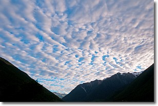
Weather Topic: What are Altocumulus Clouds?
Home - Education - Cloud Types - Altocumulus Clouds
 Next Topic: Altostratus Clouds
Similar to cirrocumulus clouds, altocumulus clouds are
characterized by cloud patches. They are distinguished by larger cloudlets
than cirrocumulus clouds but are still smaller than stratocumulus clouds.
Altocumulus clouds most commonly form in middle altitudes (between 2 and 5 km)
and may resemble, at times, the shape of a flying saucer.
These uncommon formations, called altocumulus lenticularis, are created by uplift
in the atmosphere and are most often seen in close proximity to mountains.
Next Topic: Altostratus Clouds


