Weather Alert in Texas
Red Flag Warning issued March 14 at 4:33AM CDT until March 14 at 9:00PM CDT by NWS Houston/Galveston TX
AREAS AFFECTED: Houston
DESCRIPTION: ...Elevated to Critical Fire Weather Conditions Expected Today and Saturday... .Elevated to critical fire weather conditions are expected across portions of Southeast Texas. Southwest winds around 15 to 20 mph alongside relative humidity values in the upper teens to middle 20s today will lead to critical fire weather conditions primarily in the Brazos Valley, and extending northeastward towards the Piney Woods. More widespread low relative humidity values in the teens and 20s is expected on Saturday alongside gusty westerly winds. This creates a more widespread critical fire weather threat. * WINDS...Southwest 5 to 15 mph with frequent gusts up to 30 mph. * RELATIVE HUMIDITY...Middle 20s to around 30 percent. * TEMPERATURES...Around 85 degrees. * IMPACTS...Any wildfires that start could rapidly increase in size and intensity, and move quickly.
INSTRUCTION: A Red Flag Warning means that critical fire weather conditions are either occurring now...or will shortly. A combination of strong winds...low relative humidity...and warm temperatures will create explosive fire growth potential.
Want more detail? Get the Complete 7 Day and Night Detailed Forecast!
Current U.S. National Radar--Current
The Current National Weather Radar is shown below with a UTC Time (subtract 5 hours from UTC to get Eastern Time).

National Weather Forecast--Current
The Current National Weather Forecast and National Weather Map are shown below.

National Weather Forecast for Tomorrow
Tomorrow National Weather Forecast and Tomorrow National Weather Map are show below.

North America Water Vapor (Moisture)
This map shows recent moisture content over North America. Bright and colored areas show high moisture (ie, clouds); brown indicates very little moisture present; black indicates no moisture.

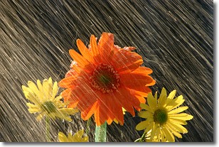
Weather Topic: What is Rain?
Home - Education - Precipitation - Rain
 Next Topic: Shelf Clouds
Precipitation in the form of water droplets is called rain.
Rain generally has a tendency to fall with less intensity over a greater period
of time, and when rainfall is more severe it is usually less sustained.
Rain is the most common form of precipitation and happens with greater frequency
depending on the season and regional influences. Cities have been shown to have
an observable effect on rainfall, due to an effect called the urban heat island.
Compared to upwind, monthly rainfall between twenty and forty miles downwind of
cities is 30% greater.
Next Topic: Shelf Clouds
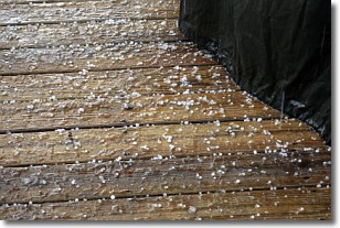
Weather Topic: What is Sleet?
Home - Education - Precipitation - Sleet
 Next Topic: Snow
Sleet is a form of precipitation in which small ice pellets are the primary
components. These ice pellets are smaller and more translucent than hailstones,
and harder than graupel. Sleet is caused by specific atmospheric conditions and
therefore typically doesn't last for extended periods of time.
The condition which leads to sleet formation requires a warmer body of air to be
wedged in between two sub-freezing bodies of air. When snow falls through a warmer
layer of air it melts, and as it falls through the next sub-freezing body of air
it freezes again, forming ice pellets known as sleet. In some cases, water
droplets don't have time to freeze before reaching the surface and the result is
freezing rain.
Next Topic: Snow


