Weather Alert in Texas
Red Flag Warning issued March 14 at 4:33AM CDT until March 14 at 9:00PM CDT by NWS Houston/Galveston TX
AREAS AFFECTED: Madison; Burleson; Brazos; Washington; Grimes
DESCRIPTION: ...Elevated to Critical Fire Weather Conditions Expected Today and Saturday... .Elevated to critical fire weather conditions are expected across portions of Southeast Texas. Southwest winds around 15 to 20 mph alongside relative humidity values in the upper teens to middle 20s today will lead to critical fire weather conditions primarily in the Brazos Valley, and extending northeastward towards the Piney Woods. More widespread low relative humidity values in the teens and 20s is expected on Saturday alongside gusty westerly winds. This creates a more widespread critical fire weather threat. * WINDS...West 10 to 20 mph with gusts up to 30 mph. * RELATIVE HUMIDITY...19-25 percent. * TEMPERATURES...Upper 80s. * IMPACTS...Any wildfires that start could rapidly increase in size and intensity, and move quickly.
INSTRUCTION: A Red Flag Warning means that critical fire weather conditions are either occurring now...or will shortly. A combination of strong winds...low relative humidity...and warm temperatures will create explosive fire growth potential. A Fire Weather Watch means that critical fire weather conditions are forecast to occur. Listen for later forecasts and possible Red Flag Warnings.
Want more detail? Get the Complete 7 Day and Night Detailed Forecast!
Current U.S. National Radar--Current
The Current National Weather Radar is shown below with a UTC Time (subtract 5 hours from UTC to get Eastern Time).

National Weather Forecast--Current
The Current National Weather Forecast and National Weather Map are shown below.

National Weather Forecast for Tomorrow
Tomorrow National Weather Forecast and Tomorrow National Weather Map are show below.

North America Water Vapor (Moisture)
This map shows recent moisture content over North America. Bright and colored areas show high moisture (ie, clouds); brown indicates very little moisture present; black indicates no moisture.

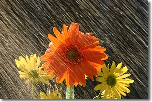
Weather Topic: What is Precipitation?
Home - Education - Precipitation - Precipitation
 Next Topic: Rain
Precipitation can refer to many different forms of water that
may fall from clouds. Precipitation occurs after a cloud has become saturated to
the point where its water particles are more dense than the air below the cloud.
In most cases, precipitation will reach the ground, but it is not uncommon for
precipitation to evaporate before it reaches the earth's surface.
When precipitation evaporates before it contacts the ground it is called Virga.
Graupel, hail, sleet, rain, drizzle, and snow are forms of precipitation, but fog
and mist are not considered precipitation because the water vapor which
constitutes them isn't dense enough to fall to the ground.
Next Topic: Rain
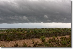
Weather Topic: What are Shelf Clouds?
Home - Education - Cloud Types - Shelf Clouds
 Next Topic: Sleet
A shelf cloud is similar to a wall cloud, but forms at the front
of a storm cloud, instead of at the rear, where wall clouds form.
A shelf cloud is caused by a series of events set into motion by the advancing
storm; first, cool air settles along the ground where precipitation has just fallen.
As the cool air is brought in, the warmer air is displaced, and rises above it,
because it is less dense. When the warmer air reaches the bottom of the storm cloud,
it begins to cool again, and the resulting condensation is a visible shelf cloud.
Next Topic: Sleet


