Weather Alert in California
Winter Storm Watch issued March 13 at 1:39AM PDT until March 14 at 11:00PM PDT by NWS Sacramento CA
AREAS AFFECTED: Western Plumas County/Lassen Park
DESCRIPTION: * WHAT...For the Winter Storm Warning Above 4000 feet, heavy snow. Additional snow accumulations of 8 to 12 inches, up to 18 inches over peaks. For the Winter Storm Watch Above 2000 feet, heavy snow possible. Total snow accumulations between 6 to 12 inches possible. Winds could gust as high as 50 mph. * WHERE...Western Plumas County/Lassen Park. * WHEN...For the Winter Storm Warning, until 11 PM PDT this evening. For the Winter Storm Watch, from 11 PM PDT tonight through Friday evening. * IMPACTS...Travel could be very difficult to impossible at times. The hazardous conditions will impact commutes through Friday evening. Strong winds could cause tree damage. * ADDITIONAL DETAILS...For the Warning, heaviest snowfall expected through this evening. For the Watch, heaviest snowfall expected Friday morning through Friday evening.
INSTRUCTION: Check the latest road conditions from Caltrans online at quickmap.dot.ca.gov or dial 5 1 1. Persons should delay travel if possible. If travel is absolutely necessary, drive with extreme caution and be prepared for sudden changes in visibility. Consider taking a winter storm kit along with you and anything else that would help you survive in case you become stranded.
Want more detail? Get the Complete 7 Day and Night Detailed Forecast!
Current U.S. National Radar--Current
The Current National Weather Radar is shown below with a UTC Time (subtract 5 hours from UTC to get Eastern Time).

National Weather Forecast--Current
The Current National Weather Forecast and National Weather Map are shown below.

National Weather Forecast for Tomorrow
Tomorrow National Weather Forecast and Tomorrow National Weather Map are show below.

North America Water Vapor (Moisture)
This map shows recent moisture content over North America. Bright and colored areas show high moisture (ie, clouds); brown indicates very little moisture present; black indicates no moisture.

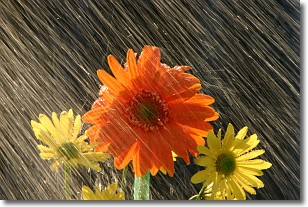
Weather Topic: What is Precipitation?
Home - Education - Precipitation - Precipitation
 Next Topic: Rain
Precipitation can refer to many different forms of water that
may fall from clouds. Precipitation occurs after a cloud has become saturated to
the point where its water particles are more dense than the air below the cloud.
In most cases, precipitation will reach the ground, but it is not uncommon for
precipitation to evaporate before it reaches the earth's surface.
When precipitation evaporates before it contacts the ground it is called Virga.
Graupel, hail, sleet, rain, drizzle, and snow are forms of precipitation, but fog
and mist are not considered precipitation because the water vapor which
constitutes them isn't dense enough to fall to the ground.
Next Topic: Rain
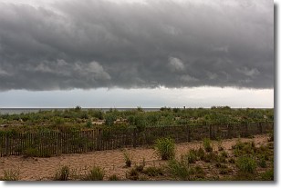
Weather Topic: What are Shelf Clouds?
Home - Education - Cloud Types - Shelf Clouds
 Next Topic: Sleet
A shelf cloud is similar to a wall cloud, but forms at the front
of a storm cloud, instead of at the rear, where wall clouds form.
A shelf cloud is caused by a series of events set into motion by the advancing
storm; first, cool air settles along the ground where precipitation has just fallen.
As the cool air is brought in, the warmer air is displaced, and rises above it,
because it is less dense. When the warmer air reaches the bottom of the storm cloud,
it begins to cool again, and the resulting condensation is a visible shelf cloud.
Next Topic: Sleet


