Weather Alert in California
Winter Storm Warning issued March 13 at 1:39AM PDT until March 13 at 11:00PM PDT by NWS Sacramento CA
AREAS AFFECTED: Western Plumas County/Lassen Park
DESCRIPTION: * WHAT...For the Winter Storm Warning Above 4000 feet, heavy snow. Additional snow accumulations of 8 to 12 inches, up to 18 inches over peaks. For the Winter Storm Watch Above 2000 feet, heavy snow possible. Total snow accumulations between 6 to 12 inches possible. Winds could gust as high as 50 mph. * WHERE...Western Plumas County/Lassen Park. * WHEN...For the Winter Storm Warning, until 11 PM PDT this evening. For the Winter Storm Watch, from 11 PM PDT tonight through Friday evening. * IMPACTS...Travel could be very difficult to impossible at times. The hazardous conditions will impact commutes through Friday evening. Strong winds could cause tree damage. * ADDITIONAL DETAILS...For the Warning, heaviest snowfall expected through this evening. For the Watch, heaviest snowfall expected Friday morning through Friday evening.
INSTRUCTION: Check the latest road conditions from Caltrans online at quickmap.dot.ca.gov or dial 5 1 1. Persons should delay travel if possible. If travel is absolutely necessary, drive with extreme caution and be prepared for sudden changes in visibility. Consider taking a winter storm kit along with you and anything else that would help you survive in case you become stranded.
Want more detail? Get the Complete 7 Day and Night Detailed Forecast!
Current U.S. National Radar--Current
The Current National Weather Radar is shown below with a UTC Time (subtract 5 hours from UTC to get Eastern Time).

National Weather Forecast--Current
The Current National Weather Forecast and National Weather Map are shown below.

National Weather Forecast for Tomorrow
Tomorrow National Weather Forecast and Tomorrow National Weather Map are show below.

North America Water Vapor (Moisture)
This map shows recent moisture content over North America. Bright and colored areas show high moisture (ie, clouds); brown indicates very little moisture present; black indicates no moisture.

Weather Topic: What is Condensation?
Home - Education - Precipitation - Condensation
 Next Topic: Contrails
Condensation is the process which creates clouds, and therefore
it is a crucial process in the water cycle.
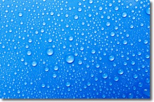
Condensation is the change of matter from a state of gas into a state of liquid,
and it happens because water molecules release heat into the atmosphere and
become organized into a more closely packed structure, what we might see as
water droplets.
Water is always present in the air around us as a vapor, but it's too small for
us to see. When water undergoes the process of condensation it becomes organized
into visible water droplets. You've probably seen condensation happen before on the
surface of a cold drink!
Next Topic: Contrails
Weather Topic: What are Cumulonimbus Clouds?
Home - Education - Cloud Types - Cumulonimbus Clouds
 Next Topic: Cumulus Clouds
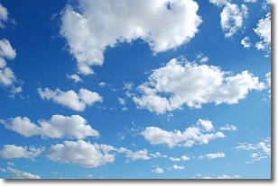
The final form taken by a growing cumulus cloud is the
cumulonimbus cloud, which is very tall and dense.
The tower of a cumulonimbus cloud can soar 23 km into the atmosphere, although
most commonly they stop growing at an altitude of 6 km.
Even small cumulonimbus clouds appear very large in comparison to other cloud types.
They can signal the approach of stormy weather, such as thunderstorms or blizzards.
Next Topic: Cumulus Clouds


