Weather Alert in California
Wind Advisory issued March 31 at 12:16AM PDT until April 1 at 11:00PM PDT by NWS Phoenix AZ
AREAS AFFECTED: Imperial County West; Imperial Valley
DESCRIPTION: * WHAT...For the first Wind Advisory, west winds 15 to 25 mph with gusts up to 40 mph expected. For the second Wind Advisory, west winds 20 to 30 mph with gusts up to 45 mph expected. * WHERE...Western Imperial County, and Imperial Valley. * WHEN...For the first Wind Advisory, from 3 PM this afternoon to 11 PM PDT this evening. For the second Wind Advisory, from 3 PM to 11 PM PDT Tuesday. * IMPACTS...Difficult driving conditions, especially for larger vehicles traveling along roads with crosswinds. Light, unsecured objects may become airborne.
INSTRUCTION: A Wind Advisory means that sustained wind speeds of between 30 and 40 mph are expected, or wind gusts of between 40 and 58 mph. Winds this strong can make driving difficult, especially for high profile vehicles. In addition, strong winds over desert areas could result in briefly lowered visibilities to well under a mile at times in blowing dust or blowing sand. Use extra caution.
Want more detail? Get the Complete 7 Day and Night Detailed Forecast!
Current U.S. National Radar--Current
The Current National Weather Radar is shown below with a UTC Time (subtract 5 hours from UTC to get Eastern Time).

National Weather Forecast--Current
The Current National Weather Forecast and National Weather Map are shown below.

National Weather Forecast for Tomorrow
Tomorrow National Weather Forecast and Tomorrow National Weather Map are show below.

North America Water Vapor (Moisture)
This map shows recent moisture content over North America. Bright and colored areas show high moisture (ie, clouds); brown indicates very little moisture present; black indicates no moisture.

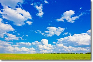
Weather Topic: What are Cumulus Clouds?
Home - Education - Cloud Types - Cumulus Clouds
 Next Topic: Drizzle
Cumulus clouds are fluffy and textured with rounded tops, and
may have flat bottoms. The border of a cumulus cloud
is clearly defined, and can have the appearance of cotton or cauliflower.
Cumulus clouds form at low altitudes (rarely above 2 km) but can grow very tall,
becoming cumulus congestus and possibly the even taller cumulonimbus clouds.
When cumulus clouds become taller, they have a greater chance of producing precipitation.
Next Topic: Drizzle
Weather Topic: What is Evaporation?
Home - Education - Precipitation - Evaporation
 Next Topic: Fog
Evaporation is the process which returns water from the earth
back to the atmosphere, and is another crucial process in the water cycle.
Evaporation is the transformation of liquid into gas, and it happens because
molecules are excited by the application of energy and turn into vapor.
In order for water to evaporate it has to be on the surface of a body of water.
Next Topic: Fog
Current conditions powered by WeatherAPI.com


