Weather Alert in California
Wind Advisory issued April 1 at 3:52AM PDT until April 2 at 2:00AM PDT by NWS Los Angeles/Oxnard CA
AREAS AFFECTED: Catalina and Santa Barbara Islands; Santa Clarita Valley; Santa Barbara County Southeastern Coast; Ventura County Beaches; Ventura County Inland Coast; Lake Casitas; Ojai Valley; Central Ventura County Valleys; Malibu Coast; Los Angeles County Beaches; Palos Verdes Hills; Los Angeles County Inland Coast including Downtown Los Angeles; Western Santa Monica Mountains Recreational Area; Eastern Santa Monica Mountains Recreational Area; Calabasas and Agoura Hills; Western San Fernando Valley; Eastern San Fernando Valley; Southeastern Ventura County Valleys; Santa Susana Mountains; Los Angeles County San Gabriel Valley
DESCRIPTION: * WHAT...West winds 20 to 30 mph with gusts up to 50 mph expected. * WHERE...Much of the Los Angeles and Ventura County coast and valleys, the southern Santa Barbara County South Coast, and the Santa Ynez Valley. * WHEN...From 10 AM this morning to 2 AM PDT Wednesday. * IMPACTS...Difficult driving conditions expected, especially for motor homes and big rigs. Unsecured objects will be blown around. Tree limbs could be blown down and a few power outages may result.
INSTRUCTION: Winds this strong can make driving difficult, especially for high profile vehicles. Use extra caution.
Want more detail? Get the Complete 7 Day and Night Detailed Forecast!
Current U.S. National Radar--Current
The Current National Weather Radar is shown below with a UTC Time (subtract 5 hours from UTC to get Eastern Time).

National Weather Forecast--Current
The Current National Weather Forecast and National Weather Map are shown below.

National Weather Forecast for Tomorrow
Tomorrow National Weather Forecast and Tomorrow National Weather Map are show below.

North America Water Vapor (Moisture)
This map shows recent moisture content over North America. Bright and colored areas show high moisture (ie, clouds); brown indicates very little moisture present; black indicates no moisture.

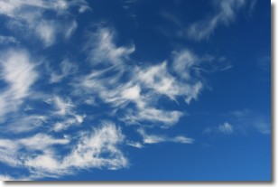
Weather Topic: What are Cirrostratus Clouds?
Home - Education - Cloud Types - Cirrostratus Clouds
 Next Topic: Cirrus Clouds
Cirrostratus clouds are high, thin clouds that form above
20,000 feet and are made mostly of ice crystals. They sometimes look like giant
feathers, horse tails, or curls of hair in the sky.
These clouds are pushed by the jet stream and can move at high speeds reaching
100 mph.
What do they indicate?
They indicate that a precipitation is likely within 24 hours.
Next Topic: Cirrus Clouds
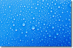
Weather Topic: What is Condensation?
Home - Education - Precipitation - Condensation
 Next Topic: Contrails
Condensation is the process which creates clouds, and therefore
it is a crucial process in the water cycle.
Condensation is the change of matter from a state of gas into a state of liquid,
and it happens because water molecules release heat into the atmosphere and
become organized into a more closely packed structure, what we might see as
water droplets.
Water is always present in the air around us as a vapor, but it's too small for
us to see. When water undergoes the process of condensation it becomes organized
into visible water droplets. You've probably seen condensation happen before on the
surface of a cold drink!
Next Topic: Contrails
Current conditions powered by WeatherAPI.com


