Weather Alert in Colorado
Red Flag Warning issued March 31 at 3:31AM MDT until March 31 at 9:00PM MDT by NWS Pueblo CO
AREAS AFFECTED: Pueblo County Including Pueblo; Huerfano County Including Walsenburg; Western Las Animas County Including Trinidad and Thatcher; Otero County Including La Junta and Western Comanche Grasslands; Eastern Las Animas County Including Pinon Canyon
DESCRIPTION: The National Weather Service in Pueblo has issued a Red Flag Warning for gusty winds and low relative humidity, which is in effect from noon to 7 PM MDT Tuesday. The Fire Weather Watch is no longer in effect. * AFFECTED AREA...Fire Weather Zones 228, 229, 230, 232 and 233. * WINDS...For today, west winds 20 to 30 mph with gusts to 45 mph. For Tuesday, southwest 30 to 40 mph with gusts up to 60 mph. * RELATIVE HUMIDITY...10 to 15 percent. * IMPACTS...Fires will catch and spread quickly. Exercise extreme caution with any outdoor burning.
INSTRUCTION: A Red Flag Warning means that critical fire weather conditions are either occurring now, or will shortly. A combination of strong winds, low relative humidity, and warm temperatures can contribute to extreme fire behavior.
Want more detail? Get the Complete 7 Day and Night Detailed Forecast!
Current U.S. National Radar--Current
The Current National Weather Radar is shown below with a UTC Time (subtract 5 hours from UTC to get Eastern Time).

National Weather Forecast--Current
The Current National Weather Forecast and National Weather Map are shown below.

National Weather Forecast for Tomorrow
Tomorrow National Weather Forecast and Tomorrow National Weather Map are show below.

North America Water Vapor (Moisture)
This map shows recent moisture content over North America. Bright and colored areas show high moisture (ie, clouds); brown indicates very little moisture present; black indicates no moisture.

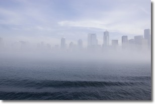
Weather Topic: What is Fog?
Home - Education - Cloud Types - Fog
 Next Topic: Fractus Clouds
Fog is technically a type of stratus cloud, which lies along the
ground and obscures visibility.
It is usually created when humidity in the air condenses into tiny water droplets.
Because of this, some places are more prone to foggy weather, such as regions
close to a body of water.
Fog is similar to mist; both are the appearance of water droplets suspended in
the air, but fog is the term applied to the condition when visibility is less than 1 km.
Next Topic: Fractus Clouds
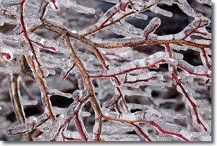
Weather Topic: What is Freezing Rain?
Home - Education - Precipitation - Freezing Rain
 Next Topic: Graupel
Freezing rain is a condition where precipitation which has fallen in the form of
water droplets reaches temperatures which are below freezing and freezes upon
coming into contact
with surface objects. The result of this precipitation is a glaze of ice which
can be damaging to plants and man-made structures. A severe onset of freezing
rain which results in a very thick glaze of ice is known as an ice storm.
Next Topic: Graupel
Current conditions powered by WeatherAPI.com


