Weather Alert in Arizona
Red Flag Warning issued March 31 at 1:59AM MST until April 1 at 8:00PM MST by NWS Tucson AZ
AREAS AFFECTED: Pima-South Central Pinal-Tohono Oodham Nation; Eastern Pima-Southeastern Pinal-Santa Cruz-Western Cochise; Southern Graham-Central and Eastern Cochise-Southern Greenlee-Lower Elevations of the San Carlos Apache Nation in Graham County
DESCRIPTION: The National Weather Service in Tucson has issued a Red Flag Warning for strong and gusty winds, low relative humidity, and high fire danger, which is in effect from 1 PM to 8 PM MST Tuesday. The Fire Weather Watch is no longer in effect. * AFFECTED AREA...Fire Weather Zones 150, 151 and 152. This includes locations below 5000 feet in Cochise, Graham, Greenlee, Santa Cruz, Central and Eastern Pima and Southeast Pinal counties. * TIMING...From 1 PM to 8 PM MST Tuesday. * WINDS...West 20 to 30 mph with gusts 45-50 mph. * RELATIVE HUMIDITY...10 to 15 percent. * IMPACTS...Any fires that develop or are ongoing will have the potential to spread rapidly.
INSTRUCTION: A Red Flag Warning means that critical fire weather conditions are either occurring now...or are expected to develop. A combination of strong winds...low relative humidity...and dry vegetation will create the potential for rapid and erratic fire growth. Please advise the appropriate officials or fire crews in the field of the Red Flag Warning for portions of Southeast Arizona.
Want more detail? Get the Complete 7 Day and Night Detailed Forecast!
Current U.S. National Radar--Current
The Current National Weather Radar is shown below with a UTC Time (subtract 5 hours from UTC to get Eastern Time).

National Weather Forecast--Current
The Current National Weather Forecast and National Weather Map are shown below.

National Weather Forecast for Tomorrow
Tomorrow National Weather Forecast and Tomorrow National Weather Map are show below.

North America Water Vapor (Moisture)
This map shows recent moisture content over North America. Bright and colored areas show high moisture (ie, clouds); brown indicates very little moisture present; black indicates no moisture.

Weather Topic: What is Condensation?
Home - Education - Precipitation - Condensation
 Next Topic: Contrails
Condensation is the process which creates clouds, and therefore
it is a crucial process in the water cycle.
Condensation is the change of matter from a state of gas into a state of liquid,
and it happens because water molecules release heat into the atmosphere and
become organized into a more closely packed structure, what we might see as
water droplets.
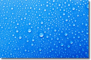
Water is always present in the air around us as a vapor, but it's too small for
us to see. When water undergoes the process of condensation it becomes organized
into visible water droplets. You've probably seen condensation happen before on the
surface of a cold drink!
Next Topic: Contrails
Weather Topic: What are Cumulonimbus Clouds?
Home - Education - Cloud Types - Cumulonimbus Clouds
 Next Topic: Cumulus Clouds
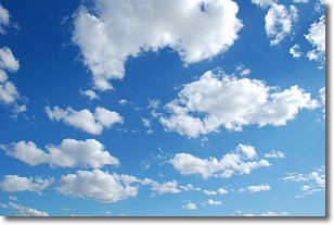
The final form taken by a growing cumulus cloud is the
cumulonimbus cloud, which is very tall and dense.
The tower of a cumulonimbus cloud can soar 23 km into the atmosphere, although
most commonly they stop growing at an altitude of 6 km.
Even small cumulonimbus clouds appear very large in comparison to other cloud types.
They can signal the approach of stormy weather, such as thunderstorms or blizzards.
Next Topic: Cumulus Clouds
Current conditions powered by WeatherAPI.com


