Weather Alert in Wisconsin
Flood Warning issued April 24 at 2:16AM CDT until April 25 at 1:00AM CDT by NWS La Crosse WI
AREAS AFFECTED: La Crosse, WI; Trempealeau, WI
DESCRIPTION: ...The Flood Warning is extended for the following rivers in Wisconsin... Yellow River at Necedah affecting Juneau County. ...The Flood Warning continues for the following rivers in Wisconsin... Black River Near Galesville affecting Trempealeau and La Crosse Counties. .Recent rains has caused the Yellow River at Necedah and the Black River near Galesville to climb above minor flood stage. * WHAT...Minor flooding is occurring and minor flooding is forecast. * WHERE...Black River near Galesville. * WHEN...Until just after midnight tonight. * IMPACTS...At 12.0 feet, Flooding mainly impacts wildlands and agricultural pasture land. However the approach to the south end of the County Road VV Bridge over the Black River may be flooded. * ADDITIONAL DETAILS... - At 1:00 AM CDT Thursday the stage was 12.2 feet. - Bankfull stage is 10.0 feet. - Recent Activity...The maximum river stage in the 24 hours ending at 1:00 AM CDT Thursday was 12.2 feet. - Forecast...The river is expected to fall below flood stage this afternoon and continue falling to 5.2 feet Wednesday evening. - Flood stage is 12.0 feet. - Flood History...This crest compares to a previous crest of 12.3 feet on 09/29/1972. - http://www.weather.gov/safety/flood
INSTRUCTION: Turn around, don't drown when encountering flooded roads. Most flood deaths occur in vehicles. Be especially cautious at night when it is harder to recognize the dangers of flooding. Additional river and weather information is available at www.weather.gov/lacrosse. The next statement will be issued late tonight at 100 AM CDT.
Want more detail? Get the Complete 7 Day and Night Detailed Forecast!
Current U.S. National Radar--Current
The Current National Weather Radar is shown below with a UTC Time (subtract 5 hours from UTC to get Eastern Time).

National Weather Forecast--Current
The Current National Weather Forecast and National Weather Map are shown below.

National Weather Forecast for Tomorrow
Tomorrow National Weather Forecast and Tomorrow National Weather Map are show below.

North America Water Vapor (Moisture)
This map shows recent moisture content over North America. Bright and colored areas show high moisture (ie, clouds); brown indicates very little moisture present; black indicates no moisture.

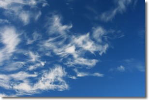
Weather Topic: What are Cirrostratus Clouds?
Home - Education - Cloud Types - Cirrostratus Clouds
 Next Topic: Cirrus Clouds
Cirrostratus clouds are high, thin clouds that form above
20,000 feet and are made mostly of ice crystals. They sometimes look like giant
feathers, horse tails, or curls of hair in the sky.
These clouds are pushed by the jet stream and can move at high speeds reaching
100 mph.
What do they indicate?
They indicate that a precipitation is likely within 24 hours.
Next Topic: Cirrus Clouds
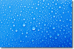
Weather Topic: What is Condensation?
Home - Education - Precipitation - Condensation
 Next Topic: Contrails
Condensation is the process which creates clouds, and therefore
it is a crucial process in the water cycle.
Condensation is the change of matter from a state of gas into a state of liquid,
and it happens because water molecules release heat into the atmosphere and
become organized into a more closely packed structure, what we might see as
water droplets.
Water is always present in the air around us as a vapor, but it's too small for
us to see. When water undergoes the process of condensation it becomes organized
into visible water droplets. You've probably seen condensation happen before on the
surface of a cold drink!
Next Topic: Contrails
Current conditions powered by WeatherAPI.com


