Weather Alert in Texas
Fire Weather Watch issued March 14 at 4:09AM CDT until March 15 at 6:00PM CDT by NWS Brownsville TX
AREAS AFFECTED: Zapata; Jim Hogg; Brooks; Inland Kenedy; Starr; Southern Hidalgo; Inland Willacy; Inland Cameron; Coastal Kenedy; Northern Hidalgo; Coastal Willacy; Coastal Cameron
DESCRIPTION: ...A FIRE WEATHER WATCH IS IN EFFECT SATURDAY FOR ALL OF DEEP SOUTH TEXAS EXCEPT THE IMMEDIATE COASTAL ISLAND COUNTIES... .Plummeting relative humidity and increasing northwest winds behind a Saturday morning cold front will favorable for elevated to critical fire weather conditions. Cured to critical dry fuels could experience rapid growth and spread with some erratic fire behavior. * AFFECTED AREA...Zapata, Jim Hogg, Brooks, Inland Kenedy, Starr, Southern Hidalgo, Inland Willacy, Inland Cameron, Coastal Kenedy, Northern Hidalgo, Coastal Willacy and Coastal Cameron. * TIMING...From Saturday morning through Saturday afternoon. * WINDS...Northwest 15 to 20 mph with gusts up to 30 mph. * RELATIVE HUMIDITY...As low as 10 percent. * IMPACTS...Any fire that develops will catch and spread quickly. Outdoor burning is not recommended.
INSTRUCTION: A Fire Weather Watch means that critical fire weather conditions are forecast to occur. Listen for later forecasts and possible Red Flag Warnings.
Want more detail? Get the Complete 7 Day and Night Detailed Forecast!
Current U.S. National Radar--Current
The Current National Weather Radar is shown below with a UTC Time (subtract 5 hours from UTC to get Eastern Time).

National Weather Forecast--Current
The Current National Weather Forecast and National Weather Map are shown below.

National Weather Forecast for Tomorrow
Tomorrow National Weather Forecast and Tomorrow National Weather Map are show below.

North America Water Vapor (Moisture)
This map shows recent moisture content over North America. Bright and colored areas show high moisture (ie, clouds); brown indicates very little moisture present; black indicates no moisture.

Weather Topic: What are Fractus Clouds?
Home - Education - Cloud Types - Fractus Clouds
 Next Topic: Freezing Rain
A fractus cloud (scud) is a fragmented, tattered cloud which has
likely been sheared off of another cloud. They are accessory clouds, meaning they
develop from parent clouds, and are named in a way which describes the original
cloud which contained them.
Fractus clouds which have originated from cumulus clouds are referred to as
cumulus fractus, while fractus clouds which have originated from stratus clouds
are referred to as stratus fractus. Under certain conditions a fractus cloud might
merge with another cloud, or develop into a cumulus cloud, but usually a
fractus cloud seen by itself will dissipate rapidly.
They are often observed on the leading and trailing edges of storm clouds,
and are a display of wind activity.
Next Topic: Freezing Rain
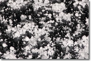
Weather Topic: What is Graupel?
Home - Education - Precipitation - Graupel
 Next Topic: Hail
Graupel is a form of precipitation that is created by atmospheric conditions
which cause supercooled water droplets to contact snow crystals and freeze to
their surface.
Sometimes known as soft hail or snow pellets, graupel is delicate and easily
destroyed by touch. Whereas hail usually falls during severe weather, graupel
doesn't require such conditions to form, and can form in mild precipitation
similar to situations which produce snowfall.
Next Topic: Hail


