Weather Alert in Minnesota
Winter Storm Watch issued March 14 at 6:52AM CDT until March 15 at 7:00PM CDT by NWS Aberdeen SD
AREAS AFFECTED: Traverse; Big Stone; Brown; Marshall; Roberts; Day; Spink; Clark; Codington; Grant; Hamlin; Deuel
DESCRIPTION: * WHAT...Blizzard conditions possible. Total snow and sleet accumulations up to 7 inches and ice accumulations around a light glaze possible. Winds could gust as high as 55 mph. Highest snow totals across the I-29 corridor into western Minnesota, lowest over the James River valley. * WHERE...Portions of west central Minnesota and northeast South Dakota. * WHEN...From late tonight through Saturday evening. * IMPACTS...Visibilities may drop below 1/4 mile due to falling and blowing snow. Whiteout conditions are possible and may make travel treacherous and potentially life-threatening. Travel could be very difficult. Widespread blowing snow could significantly reduce visibility. Strong winds could cause tree damage.
INSTRUCTION: Prepare for possible blizzard conditions. Continue to monitor the latest forecasts for updates on this situation. Persons should consider delaying all travel. If travel is absolutely necessary, drive with extreme caution. Consider taking a winter storm kit along with you, including such items as tire chains, booster cables, flashlight, shovel, blankets and extra clothing. Also take water, a first aid kit, and anything else that would help you survive in case you become stranded.
Want more detail? Get the Complete 7 Day and Night Detailed Forecast!
Current U.S. National Radar--Current
The Current National Weather Radar is shown below with a UTC Time (subtract 5 hours from UTC to get Eastern Time).

National Weather Forecast--Current
The Current National Weather Forecast and National Weather Map are shown below.

National Weather Forecast for Tomorrow
Tomorrow National Weather Forecast and Tomorrow National Weather Map are show below.

North America Water Vapor (Moisture)
This map shows recent moisture content over North America. Bright and colored areas show high moisture (ie, clouds); brown indicates very little moisture present; black indicates no moisture.

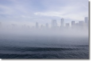
Weather Topic: What is Fog?
Home - Education - Cloud Types - Fog
 Next Topic: Fractus Clouds
Fog is technically a type of stratus cloud, which lies along the
ground and obscures visibility.
It is usually created when humidity in the air condenses into tiny water droplets.
Because of this, some places are more prone to foggy weather, such as regions
close to a body of water.
Fog is similar to mist; both are the appearance of water droplets suspended in
the air, but fog is the term applied to the condition when visibility is less than 1 km.
Next Topic: Fractus Clouds
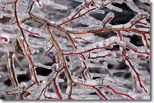
Weather Topic: What is Freezing Rain?
Home - Education - Precipitation - Freezing Rain
 Next Topic: Graupel
Freezing rain is a condition where precipitation which has fallen in the form of
water droplets reaches temperatures which are below freezing and freezes upon
coming into contact
with surface objects. The result of this precipitation is a glaze of ice which
can be damaging to plants and man-made structures. A severe onset of freezing
rain which results in a very thick glaze of ice is known as an ice storm.
Next Topic: Graupel


