Weather Alert in Washington
Winter Storm Warning issued March 14 at 3:31AM PDT until March 16 at 11:00AM PDT by NWS Pendleton OR
AREAS AFFECTED: Upper Slopes of the Eastern Washington Cascades Crest
DESCRIPTION: * WHAT...Heavy snow expected above 2000 feet. Total snow accumulations between 10 and 16 inches. Winds gusting as high as 35 mph. * WHERE...Upper Slopes of the Eastern Washington Cascades Crest. * WHEN...From 5 AM Saturday to 11 AM PDT Sunday. * IMPACTS...Significant snowfall with periods of heavy snowfall rates will combine with low visibility to create very difficult driving conditions.
INSTRUCTION: Persons should consider delaying all travel. If travel is absolutely necessary, drive with extreme caution. Consider taking a winter storm kit along with you, including such items as tire chains, booster cables, flashlight, shovel, blankets and extra clothing. Also take water, a first aid kit, and anything else that would help you survive in case you become stranded. Do not touch downed lines and report any power outages to your electric company. Travel is highly discouraged due to slick roadways and the possibility of downed trees and power lines.
Want more detail? Get the Complete 7 Day and Night Detailed Forecast!
Current U.S. National Radar--Current
The Current National Weather Radar is shown below with a UTC Time (subtract 5 hours from UTC to get Eastern Time).

National Weather Forecast--Current
The Current National Weather Forecast and National Weather Map are shown below.

National Weather Forecast for Tomorrow
Tomorrow National Weather Forecast and Tomorrow National Weather Map are show below.

North America Water Vapor (Moisture)
This map shows recent moisture content over North America. Bright and colored areas show high moisture (ie, clouds); brown indicates very little moisture present; black indicates no moisture.

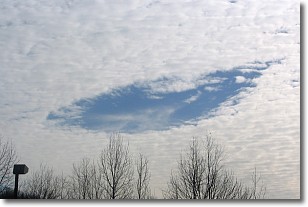
Weather Topic: What are Hole Punch Clouds?
Home - Education - Cloud Types - Hole Punch Clouds
 Next Topic: Mammatus Clouds
A hole punch cloud is an unusual occurrence when a disk-shaped
hole appears in a cirrostratus, cirrocumulus, or altocumulus cloud.
When part of the cloud forms ice crystals, water droplets in the surrounding area
of the cloud evaporate. The effect of this process produces a large elliptical
gap in the cloud. The hole punch cloud formation is rare, but it is not specific
to any geographic area.
Other names which have been used to describe this phenomena include fallstreak hole,
skypunch, and cloud hole.
Next Topic: Mammatus Clouds
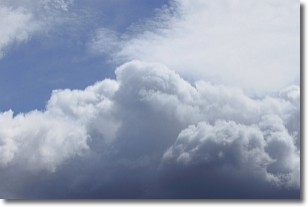
Weather Topic: What are Nimbostratus Clouds?
Home - Education - Cloud Types - Nimbostratus Clouds
 Next Topic: Precipitation
A nimbostratus cloud is similar to a stratus cloud in its formless,
smooth appearance. However, a nimbostratus cloud is darker than a stratus cloud,
because it is thicker.
Unlike a stratus cloud, a nimbostratus cloud typically brings with it the threat
of moderate to heavy precipitation. In some cases, the precipitation may evaporate
before reaching the ground, a phenomenon known as virga.
Next Topic: Precipitation


