Weather Alert in California
Wind Advisory issued March 13 at 1:11PM PDT until March 14 at 5:00PM PDT by NWS Medford OR
AREAS AFFECTED: Central Siskiyou County
DESCRIPTION: * WHAT...South winds 25 to 35 mph with gusts up to 55 mph expected. * WHERE...The Shasta Valley in central Siskiyou County, including Weed, Gazelle, Montague, and portions of Interstate 5 and highway 97. * WHEN...From 5 AM to 5 PM PDT Friday. * IMPACTS...Gusty winds will blow around or damage unsecured objects. Tree limbs could be blown down and a few power outages may result.
INSTRUCTION: Winds this strong can make driving difficult, especially for high profile vehicles. Use extra caution.
Want more detail? Get the Complete 7 Day and Night Detailed Forecast!
Current U.S. National Radar--Current
The Current National Weather Radar is shown below with a UTC Time (subtract 5 hours from UTC to get Eastern Time).

National Weather Forecast--Current
The Current National Weather Forecast and National Weather Map are shown below.

National Weather Forecast for Tomorrow
Tomorrow National Weather Forecast and Tomorrow National Weather Map are show below.

North America Water Vapor (Moisture)
This map shows recent moisture content over North America. Bright and colored areas show high moisture (ie, clouds); brown indicates very little moisture present; black indicates no moisture.

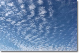
Weather Topic: What are Cirrocumulus Clouds?
Home - Education - Cloud Types - Cirrocumulus Clouds
 Next Topic: Cirrostratus Clouds
Cirrocumulus clouds form at high altitudes (usually around 5 km)
and have distinguishing characteristics displayed in a fine layer of
small cloud patches. These small cloud patches are sometimes referred to as
"cloudlets" in relation to the whole cloud formation.
Cirrocumulus clouds are formed from ice crystals and water droplets. Often, the
water droplets in the cloud freeze into ice crystals and the cloud becomes a
cirrostratus cloud. Because of this common occurrence, cirrocumulus cloud
formations generally pass rapidly.
Next Topic: Cirrostratus Clouds
Weather Topic: What are Cirrus Clouds?
Home - Education - Cloud Types - Cirrus Clouds
 Next Topic: Condensation
Cirrus clouds are high-level clouds that occur above 20,000 feet
and are composed mainly of ice crystals.
They are thin and wispy in appearance.
What do they indicate?
They are often the first sign of an approaching storm.
Next Topic: Condensation


