Weather Alert in California
Winter Weather Advisory issued March 13 at 1:57PM PDT until March 14 at 11:00PM PDT by NWS Reno NV
AREAS AFFECTED: Greater Lake Tahoe Area; Greater Lake Tahoe Area
DESCRIPTION: ...THE CURRENT WINTER STORM WARNING HAS BEEN REPLACED WITH A WINTER WEATHER ADVISORY AND WILL BE VALID THROUGH 11 PM PDT FRIDAY... * WHAT...Snow. Snow accumulations 6 to 14 inches with locally higher amounts up to 18 inches along the Sierra crest. For the eastern shore of Tahoe: snow accumulations 2 to 6 inches. Ridge winds gusting as high as 60 mph. For Lake Tahoe: southwest winds 15 to 25 mph gusting up to 40 mph with waves 2 to 3 feet. * WHERE...Greater Lake Tahoe Area. * WHEN...Until 11 PM PDT Friday. * IMPACTS...Travel could be very difficult at times. The hazardous conditions could impact the peak commutes through Friday evening. Tree limbs could be blown down and a few power outages may result from gusty winds. * ADDITIONAL DETAILS...There will be a brief break in the snowfall late tonight through early Friday morning. During that time, temperatures will remain below freezing which may lead to slippery and icy roads.
INSTRUCTION: Slow down and use caution while traveling. The latest road conditions for the state you are calling from can be obtained by calling 5 1 1.
Want more detail? Get the Complete 7 Day and Night Detailed Forecast!
Current U.S. National Radar--Current
The Current National Weather Radar is shown below with a UTC Time (subtract 5 hours from UTC to get Eastern Time).

National Weather Forecast--Current
The Current National Weather Forecast and National Weather Map are shown below.

National Weather Forecast for Tomorrow
Tomorrow National Weather Forecast and Tomorrow National Weather Map are show below.

North America Water Vapor (Moisture)
This map shows recent moisture content over North America. Bright and colored areas show high moisture (ie, clouds); brown indicates very little moisture present; black indicates no moisture.

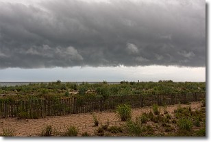
Weather Topic: What are Shelf Clouds?
Home - Education - Cloud Types - Shelf Clouds
 Next Topic: Sleet
A shelf cloud is similar to a wall cloud, but forms at the front
of a storm cloud, instead of at the rear, where wall clouds form.
A shelf cloud is caused by a series of events set into motion by the advancing
storm; first, cool air settles along the ground where precipitation has just fallen.
As the cool air is brought in, the warmer air is displaced, and rises above it,
because it is less dense. When the warmer air reaches the bottom of the storm cloud,
it begins to cool again, and the resulting condensation is a visible shelf cloud.
Next Topic: Sleet
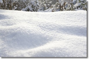
Weather Topic: What is Snow?
Home - Education - Precipitation - Snow
 Next Topic: Stratocumulus Clouds
Snow is precipitation taking the form of ice crystals. Each ice crystal, or snowflake,
has unique characteristics, but all of them grow in a hexagonal structure.
Snowfall can last for sustained periods of time and result in significant buildup
of snow on the ground.
On the earth's surface, snow starts out light and powdery, but as it begins to melt
it tends to become more granular, producing small bits of ice which have the consistency of
sand. After several cycles of melting and freezing, snow can become very dense
and ice-like, commonly known as snow pack.
Next Topic: Stratocumulus Clouds


