Weather Alert in California
Avalanche Watch issued March 30 at 8:33AM PDT by NWS Reno NV
AREAS AFFECTED: Greater Lake Tahoe Area; Greater Lake Tahoe Area
DESCRIPTION: AVAREV The following message is transmitted at the request of the U.S. Forest Service Sierra Avalanche Center. The Sierra Avalanche Center in Truckee has issued a BACKCOUNTRY AVALANCHE WATCH for the following areas: NWS Reno NV - NVZ002 (Greater Lake Tahoe)...CAZ072 (Greater Lake Tahoe (CA)) * WHAT...HIGH avalanche danger could occur in the backcountry on Monday. * WHERE...Central Sierra Nevada Mountains between Yuba Pass (Hwy 49) on the north and Ebbetts Pass (Hwy 4) on the south, including the greater Lake Tahoe area. This does not include ski areas and highways where avalanche mitigation programs exist. * WHEN...In effect from Sun 09:00 PDT to Mon 05:00 PDT. * IMPACTS...A powerful storm with rapidly accumulating snowfall and strong winds may cause widespread avalanche activity in the mountains. Large avalanches capable of burying or injuring people could occur in backcountry areas. * PRECAUTIONARY / PREPAREDNESS ACTIONS...Very dangerous avalanche conditions could occur. Traveling in, near, or below backcountry avalanche terrain during HIGH avalanche danger is not recommended. Consult https://www.sierraavalanchecenter.org/ or www.avalanche.org for more detailed information. Similar avalanche danger may exist at locations outside the coverage area of this or any avalanche center.
INSTRUCTION: N/A
Want more detail? Get the Complete 7 Day and Night Detailed Forecast!
Current U.S. National Radar--Current
The Current National Weather Radar is shown below with a UTC Time (subtract 5 hours from UTC to get Eastern Time).

National Weather Forecast--Current
The Current National Weather Forecast and National Weather Map are shown below.

National Weather Forecast for Tomorrow
Tomorrow National Weather Forecast and Tomorrow National Weather Map are show below.

North America Water Vapor (Moisture)
This map shows recent moisture content over North America. Bright and colored areas show high moisture (ie, clouds); brown indicates very little moisture present; black indicates no moisture.

Weather Topic: What is Freezing Rain?
Home - Education - Precipitation - Freezing Rain
 Next Topic: Graupel
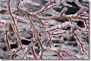
Freezing rain is a condition where precipitation which has fallen in the form of
water droplets reaches temperatures which are below freezing and freezes upon
coming into contact
with surface objects. The result of this precipitation is a glaze of ice which
can be damaging to plants and man-made structures. A severe onset of freezing
rain which results in a very thick glaze of ice is known as an ice storm.
Next Topic: Graupel
Weather Topic: What is Hail?
Home - Education - Precipitation - Hail
 Next Topic: Hole Punch Clouds
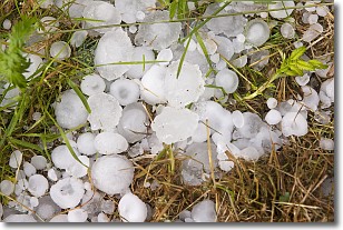
Hail is a form of precipitation which is recognized by large solid balls or
clumps of ice. Hail is created by thunderstorm clouds with strong updrafts of wind.
As the hailstones remain in the updraft, ice is deposited onto them until their
weight becomes heavy enough for them to fall to the earth's surface.
Hail storms can cause significant damage to crops, aircrafts, and man-made structures,
despite the fact that the duration is usually less than ten minutes.
Next Topic: Hole Punch Clouds
Current conditions powered by WeatherAPI.com


