Weather Alert in Louisiana
Wind Advisory issued March 14 at 3:29AM CDT until March 15 at 7:00PM CDT by NWS New Orleans LA
AREAS AFFECTED: Iberville; Assumption; St. James; St. John The Baptist; Upper Lafourche; St. Charles; Upper St. Bernard; Upper Terrebonne; Lower Terrebonne; Lower Lafourche; Coastal Jefferson; Lower Plaquemines; Lower St. Bernard; Western Orleans; Eastern Orleans; Western Ascension; Eastern Ascension; Upper Jefferson; Lower Jefferson; Upper Plaquemines; Central Plaquemines
DESCRIPTION: * WHAT...For the Dense Fog Advisory, visibility one quarter mile or less in dense fog. For the Wind Advisory, south winds 15 to 25 mph with gusts up to 40 mph expected. * WHERE...A portion of southeast Louisiana. * WHEN...For the Dense Fog Advisory, until 11 AM CDT this morning. For the Wind Advisory, from 10 AM to 7 PM CDT Saturday. * IMPACTS...Gusty winds will blow around unsecured objects. Tree limbs could be blown down and a few power outages may result. Low visibility could make driving conditions hazardous.
INSTRUCTION: Winds this strong can make driving difficult, especially for high profile vehicles. Use extra caution. Secure outdoor objects. If driving, slow down, use your low beam headlights, and leave plenty of distance ahead of you.
Want more detail? Get the Complete 7 Day and Night Detailed Forecast!
Current U.S. National Radar--Current
The Current National Weather Radar is shown below with a UTC Time (subtract 5 hours from UTC to get Eastern Time).

National Weather Forecast--Current
The Current National Weather Forecast and National Weather Map are shown below.

National Weather Forecast for Tomorrow
Tomorrow National Weather Forecast and Tomorrow National Weather Map are show below.

North America Water Vapor (Moisture)
This map shows recent moisture content over North America. Bright and colored areas show high moisture (ie, clouds); brown indicates very little moisture present; black indicates no moisture.

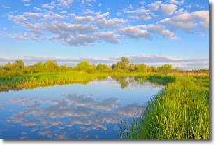
Weather Topic: What are Stratocumulus Clouds?
Home - Education - Cloud Types - Stratocumulus Clouds
 Next Topic: Stratus Clouds
Stratocumulus clouds are similar to altocumulus clouds in their
fluffy appearance, but have a slightly darker shade due to their additional mass.
A good way to distinguish the two cloud types is to hold your hand out and measure
the size of an individual cloud; if it is the size of your thumb it is generally
an altocumulus cloud, if it is the size of your hand it is generally a
stratocumulus cloud.
It is uncommon for stratocumulus clouds to produce precipitation, but if they do
it is usually a light rain or snow.
Next Topic: Stratus Clouds
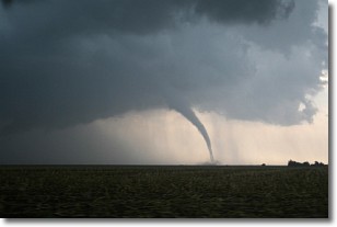
Weather Topic: What are Wall Clouds?
Home - Education - Cloud Types - Wall Clouds
 Next Topic: Altocumulus Clouds
A wall cloud forms underneath the base of a cumulonimbus cloud,
and can be a hotbed for deadly tornadoes.
Wall clouds are formed by air flowing into the cumulonimbus clouds, which can
result in the wall cloud descending from the base of the cumulonimbus cloud, or
rising fractus clouds which join to the base of the storm cloud as the wall cloud
takes shape.
Wall clouds can be very large, and in the Northern Hemisphere they generally
form at the southern edge of cumulonimbus clouds.
Next Topic: Altocumulus Clouds


