Weather Alert in Michigan
Winter Weather Advisory issued March 31 at 5:52AM EDT until March 31 at 8:00AM EDT by NWS Gaylord MI
AREAS AFFECTED: Antrim
DESCRIPTION: * WHAT...Mixed precipitation. Additional snow accumulations up to one inch and ice accumulations around a light glaze. Wind gusts up to 30mph will exacerbate impacts across areas that experienced severe icing. * WHERE...Antrim County. * WHEN...Until 8 AM EDT this morning. * IMPACTS...Roads, and especially bridges and overpasses, will likely become slick and hazardous. Plan on slippery road conditions. Gusty winds will exacerbate ongoing infrastructural and tree damage impacts well after precipitation stops this morning, with continuing travel and safety hazards from falling trees and downed electrical wires and power poles. Please be cognizant of your surroundings if you are out and about today. The hazardous conditions will impact the Monday morning commute, and will likely linger over the course of the next several days.
INSTRUCTION: Do not touch downed electrical wires. Travel is highly discouraged due to downed trees, power poles, and electrical wires.
Want more detail? Get the Complete 7 Day and Night Detailed Forecast!
Current U.S. National Radar--Current
The Current National Weather Radar is shown below with a UTC Time (subtract 5 hours from UTC to get Eastern Time).

National Weather Forecast--Current
The Current National Weather Forecast and National Weather Map are shown below.

National Weather Forecast for Tomorrow
Tomorrow National Weather Forecast and Tomorrow National Weather Map are show below.

North America Water Vapor (Moisture)
This map shows recent moisture content over North America. Bright and colored areas show high moisture (ie, clouds); brown indicates very little moisture present; black indicates no moisture.

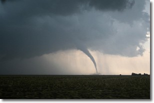
Weather Topic: What are Wall Clouds?
Home - Education - Cloud Types - Wall Clouds
 Next Topic: Altocumulus Clouds
A wall cloud forms underneath the base of a cumulonimbus cloud,
and can be a hotbed for deadly tornadoes.
Wall clouds are formed by air flowing into the cumulonimbus clouds, which can
result in the wall cloud descending from the base of the cumulonimbus cloud, or
rising fractus clouds which join to the base of the storm cloud as the wall cloud
takes shape.
Wall clouds can be very large, and in the Northern Hemisphere they generally
form at the southern edge of cumulonimbus clouds.
Next Topic: Altocumulus Clouds
Weather Topic: What are Altostratus Clouds?
Home - Education - Cloud Types - Altostratus Clouds
 Next Topic: Cirrocumulus Clouds
Altostratus clouds form at mid to high-level altitudes
(between 2 and 7 km) and are created by a warm, stable air mass which causes
water vapor
to condense as it rise through the atmosphere. Usually altostratus clouds are
featureless sheets characterized by a uniform color.
In some cases, wind punching through the cloud formation may give it a waved
appearance, called altostratus undulatus. Altostratus clouds
are commonly seen with other cloud formations accompanying them.
Next Topic: Cirrocumulus Clouds
Current conditions powered by WeatherAPI.com


