Weather Alert in Texas
Fire Weather Watch issued March 14 at 2:46AM CDT until March 15 at 9:00PM CDT by NWS Corpus Christi TX
AREAS AFFECTED: Victoria; Coastal Aransas; Inland Refugio; Inland Calhoun; Coastal Kleberg; Coastal Nueces; Coastal San Patricio; Coastal Refugio; Coastal Calhoun
DESCRIPTION: ...Red Flag Warning in Effect for Friday Afternoon... ...Fire Weather Watch in Effect for Saturday Afternoon... A dryline will swing across the region Friday afternoon ahead of our next cold front Friday night. This dryline will filter in drier air which will combine with Energy Release Component (ERC) values in the 90-97th percentile which will lead to critical fire weather conditions. For Saturday, stronger winds will enter the mix with the critically low relative humidity values dry fuels as ERC values will be above the 97th percentile. * AFFECTED AREA...Victoria, Coastal Aransas, Inland Refugio, Inland Calhoun, Coastal Kleberg, Coastal Nueces, Coastal San Patricio, Coastal Refugio and Coastal Calhoun. * TIMING...Saturday morning through the early evening hours. * WINDS...Northwest 15 to 25 mph with gusts up to 30 mph. * RELATIVE HUMIDITY...As low as 15 percent. * TEMPERATURES...Up to 85. * IMPACTS...Any fires that develop will likely spread rapidly. Outdoor burning is not recommended
INSTRUCTION: A Fire Weather Watch means that critical fire weather conditions are forecast to occur. Listen for later forecasts and possible Red Flag Warnings.
Want more detail? Get the Complete 7 Day and Night Detailed Forecast!
Current U.S. National Radar--Current
The Current National Weather Radar is shown below with a UTC Time (subtract 5 hours from UTC to get Eastern Time).

National Weather Forecast--Current
The Current National Weather Forecast and National Weather Map are shown below.

National Weather Forecast for Tomorrow
Tomorrow National Weather Forecast and Tomorrow National Weather Map are show below.

North America Water Vapor (Moisture)
This map shows recent moisture content over North America. Bright and colored areas show high moisture (ie, clouds); brown indicates very little moisture present; black indicates no moisture.

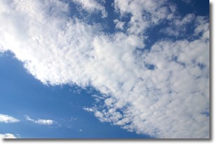
Weather Topic: What are Altocumulus Clouds?
Home - Education - Cloud Types - Altocumulus Clouds
 Next Topic: Altostratus Clouds
Similar to cirrocumulus clouds, altocumulus clouds are
characterized by cloud patches. They are distinguished by larger cloudlets
than cirrocumulus clouds but are still smaller than stratocumulus clouds.
Altocumulus clouds most commonly form in middle altitudes (between 2 and 5 km)
and may resemble, at times, the shape of a flying saucer.
These uncommon formations, called altocumulus lenticularis, are created by uplift
in the atmosphere and are most often seen in close proximity to mountains.
Next Topic: Altostratus Clouds
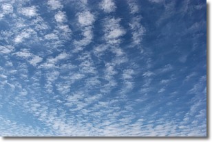
Weather Topic: What are Cirrocumulus Clouds?
Home - Education - Cloud Types - Cirrocumulus Clouds
 Next Topic: Cirrostratus Clouds
Cirrocumulus clouds form at high altitudes (usually around 5 km)
and have distinguishing characteristics displayed in a fine layer of
small cloud patches. These small cloud patches are sometimes referred to as
"cloudlets" in relation to the whole cloud formation.
Cirrocumulus clouds are formed from ice crystals and water droplets. Often, the
water droplets in the cloud freeze into ice crystals and the cloud becomes a
cirrostratus cloud. Because of this common occurrence, cirrocumulus cloud
formations generally pass rapidly.
Next Topic: Cirrostratus Clouds


