Weather Alert in Texas
Red Flag Warning issued March 14 at 2:46AM CDT until March 14 at 9:00PM CDT by NWS Corpus Christi TX
AREAS AFFECTED: La Salle; McMullen; Live Oak; Bee; Webb; Duval; Jim Wells; Inland Kleberg; Inland Nueces; Inland San Patricio
DESCRIPTION: ...Red Flag Warning in Effect for Friday Afternoon... ...Fire Weather Watch in Effect for Saturday Afternoon... A dryline will swing across the region Friday afternoon ahead of our next cold front Friday night. This dryline will filter in drier air which will combine with Energy Release Component (ERC) values in the 90-97th percentile which will lead to critical fire weather conditions. For Saturday, stronger winds will enter the mix with the critically low relative humidity values dry fuels as ERC values will be above the 97th percentile. ...FIRE WEATHER WATCH REMAINS IN EFFECT FROM SATURDAY MORNING THROUGH SATURDAY EVENING FOR CRITICALLY DRY FUELS AND CRITICALLY LOW RELATIVE HUMIDITY VALUES FOR ALL OF SOUTH TEXAS EXCEPT THE BARRIER ISLANDS... * AFFECTED AREA...La Salle, McMullen, Live Oak, Bee, Webb, Duval, Jim Wells, Inland Kleberg, Inland Nueces and Inland San Patricio. * TIMING...Late Friday and Saturday mornings through the early evening hours. * WINDS...Northwest 15 to 25 mph with gusts up to 35 mph. * RELATIVE HUMIDITY...As low as 6 percent. * TEMPERATURES...Up to 99. * IMPACTS...Any fires that develop will likely spread rapidly. Outdoor burning is not recommended
INSTRUCTION: A Red Flag Warning means that critical fire weather conditions are either occurring now...or will shortly. A combination of strong winds...low relative humidity...and warm temperatures can contribute to extreme fire behavior. Residents are urged to exercise care with respect to all outdoor activities that could inadvertently cause wildfires. Report wildfires quickly to the nearest fire department or law enforcement office. A Fire Weather Watch means that critical fire weather conditions are forecast to occur. Listen for later forecasts and possible Red Flag Warnings.
Want more detail? Get the Complete 7 Day and Night Detailed Forecast!
Current U.S. National Radar--Current
The Current National Weather Radar is shown below with a UTC Time (subtract 5 hours from UTC to get Eastern Time).

National Weather Forecast--Current
The Current National Weather Forecast and National Weather Map are shown below.

National Weather Forecast for Tomorrow
Tomorrow National Weather Forecast and Tomorrow National Weather Map are show below.

North America Water Vapor (Moisture)
This map shows recent moisture content over North America. Bright and colored areas show high moisture (ie, clouds); brown indicates very little moisture present; black indicates no moisture.

Weather Topic: What is Freezing Rain?
Home - Education - Precipitation - Freezing Rain
 Next Topic: Graupel
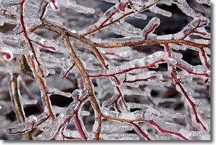
Freezing rain is a condition where precipitation which has fallen in the form of
water droplets reaches temperatures which are below freezing and freezes upon
coming into contact
with surface objects. The result of this precipitation is a glaze of ice which
can be damaging to plants and man-made structures. A severe onset of freezing
rain which results in a very thick glaze of ice is known as an ice storm.
Next Topic: Graupel
Weather Topic: What is Hail?
Home - Education - Precipitation - Hail
 Next Topic: Hole Punch Clouds
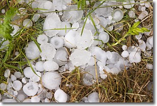
Hail is a form of precipitation which is recognized by large solid balls or
clumps of ice. Hail is created by thunderstorm clouds with strong updrafts of wind.
As the hailstones remain in the updraft, ice is deposited onto them until their
weight becomes heavy enough for them to fall to the earth's surface.
Hail storms can cause significant damage to crops, aircrafts, and man-made structures,
despite the fact that the duration is usually less than ten minutes.
Next Topic: Hole Punch Clouds


