Weather Alert in Arizona
Wind Advisory issued March 31 at 12:46PM MST until April 2 at 2:00AM MST by NWS Phoenix AZ
AREAS AFFECTED: Yuma; Salton Sea; Imperial County Southeast
DESCRIPTION: * WHAT...West winds 10 to 20 mph with gusts up to 40 mph expected. * WHERE...Southeastern Imperial County, Yuma, and Salton Sea. * WHEN...For the first Wind Advisory, until 2 AM MST /2 AM PDT/ Tuesday. For the second Wind Advisory, from 3 PM MST /3 PM PDT/ Tuesday to 2 AM MST /2 AM PDT/ Wednesday. * IMPACTS...Difficult driving conditions, especially for larger vehicles traveling along roads with crosswinds. Light, unsecured objects may become airborne.
INSTRUCTION: A Wind Advisory means that sustained wind speeds of between 30 and 40 mph are expected, or wind gusts of between 40 and 58 mph. Winds this strong can make driving difficult, especially for high profile vehicles. In addition, strong winds over desert areas could result in briefly lowered visibilities to well under a mile at times in blowing dust or blowing sand. Use extra caution.
Want more detail? Get the Complete 7 Day and Night Detailed Forecast!
Current U.S. National Radar--Current
The Current National Weather Radar is shown below with a UTC Time (subtract 5 hours from UTC to get Eastern Time).

National Weather Forecast--Current
The Current National Weather Forecast and National Weather Map are shown below.

National Weather Forecast for Tomorrow
Tomorrow National Weather Forecast and Tomorrow National Weather Map are show below.

North America Water Vapor (Moisture)
This map shows recent moisture content over North America. Bright and colored areas show high moisture (ie, clouds); brown indicates very little moisture present; black indicates no moisture.

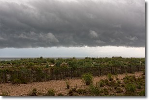
Weather Topic: What are Shelf Clouds?
Home - Education - Cloud Types - Shelf Clouds
 Next Topic: Sleet
A shelf cloud is similar to a wall cloud, but forms at the front
of a storm cloud, instead of at the rear, where wall clouds form.
A shelf cloud is caused by a series of events set into motion by the advancing
storm; first, cool air settles along the ground where precipitation has just fallen.
As the cool air is brought in, the warmer air is displaced, and rises above it,
because it is less dense. When the warmer air reaches the bottom of the storm cloud,
it begins to cool again, and the resulting condensation is a visible shelf cloud.
Next Topic: Sleet
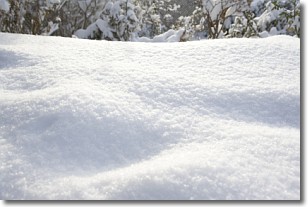
Weather Topic: What is Snow?
Home - Education - Precipitation - Snow
 Next Topic: Stratocumulus Clouds
Snow is precipitation taking the form of ice crystals. Each ice crystal, or snowflake,
has unique characteristics, but all of them grow in a hexagonal structure.
Snowfall can last for sustained periods of time and result in significant buildup
of snow on the ground.
On the earth's surface, snow starts out light and powdery, but as it begins to melt
it tends to become more granular, producing small bits of ice which have the consistency of
sand. After several cycles of melting and freezing, snow can become very dense
and ice-like, commonly known as snow pack.
Next Topic: Stratocumulus Clouds
Current conditions powered by WeatherAPI.com


