Weather Alert in Michigan
Special Weather Statement issued March 31 at 3:25AM EDT by NWS Gaylord MI
AREAS AFFECTED: Emmet; Cheboygan; Presque Isle; Antrim; Otsego; Montmorency; Alpena; Crawford; Oscoda; Alcona; Mackinac Island/Bois Blanc Island; Beaver Island and surrounding islands; Charlevoix
DESCRIPTION: Some light snow will be possible early this morning, with an inch or less of accumulation possible before snow tapers shortly after daybreak. Blustery conditions will accompany a chilly air mass across the region today, with some gusts exceeding 30mph possible this morning into the afternoon. High temperatures are anticipated to struggle to reach the lower 30s today. This will exacerbate infrastructural and tree damage impacts across the region as much of the icing from this weekend's ice storm has failed to melt off of power lines and trees. Please be cogizant of your surroundings if you are out and about today, as fallen electrical wires and power poles, along with falling trees and tree limbs will pose significant safety hazards, with roads likely to continue to become impassable at times due to being blocked by fallen debris. In addition, cold temperatures are expected across the area tonight, as low temperatures will dip well into the teens, and perhaps even upper single digits in the typical colder spots across interior northern lower Michigan. This will lead to an anomalously high risk for cold weather impacts for those enduring long duration power outages, such as frozen pipes, and may potnetially be life-threatening for those who do not have an adequate source of heating. In addition, be cognizant of long term generator operation, as improper ventilation of exhaust may lead to carbon monoxide buildup, which may be fatal. It is paramount to know the signs of carbon monoxide poisoning. If you have a carbon monoxide monitor in your house, be sure to place it low toward the floor, as carbon monoxide settles and will first be detected in lower levels.
INSTRUCTION: N/A
Want more detail? Get the Complete 7 Day and Night Detailed Forecast!
Current U.S. National Radar--Current
The Current National Weather Radar is shown below with a UTC Time (subtract 5 hours from UTC to get Eastern Time).

National Weather Forecast--Current
The Current National Weather Forecast and National Weather Map are shown below.

National Weather Forecast for Tomorrow
Tomorrow National Weather Forecast and Tomorrow National Weather Map are show below.

North America Water Vapor (Moisture)
This map shows recent moisture content over North America. Bright and colored areas show high moisture (ie, clouds); brown indicates very little moisture present; black indicates no moisture.

Weather Topic: What is Drizzle?
Home - Education - Precipitation - Drizzle
 Next Topic: Evaporation
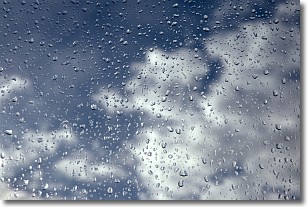
Drizzle is precipitation in the form of water droplets which are
smaller than raindrops.
Drizzle is characterized by fine, gently falling droplets and typically does not
impact human habitation in a negative way. The exception to this is freezing drizzle,
a condition where drizzle freezes immediately upon reaching earth's surface.
Freezing drizzle is still less dangerous than freezing rain, but can
potentially result in hazardous road conditions.
Next Topic: Evaporation
Weather Topic: What is Fog?
Home - Education - Cloud Types - Fog
 Next Topic: Fractus Clouds
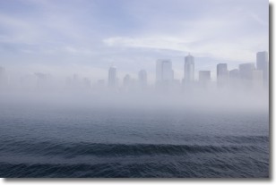
Fog is technically a type of stratus cloud, which lies along the
ground and obscures visibility.
It is usually created when humidity in the air condenses into tiny water droplets.
Because of this, some places are more prone to foggy weather, such as regions
close to a body of water.
Fog is similar to mist; both are the appearance of water droplets suspended in
the air, but fog is the term applied to the condition when visibility is less than 1 km.
Next Topic: Fractus Clouds
Current conditions powered by WeatherAPI.com


