Weather Alert in Texas
Flood Warning issued March 31 at 1:47AM CDT by NWS Shreveport LA
AREAS AFFECTED: Angelina, TX; Cherokee, TX; Nacogdoches, TX
DESCRIPTION: ...The Flood Warning continues for the following rivers in Texas... Angelina River Near Lufkin affecting Nacogdoches, Angelina and Cherokee Counties. For the Angelina River...including Alto, Lufkin...Minor flooding is forecast. * WHAT...Minor flooding is occurring and minor flooding is forecast. * WHERE...Angelina River near Lufkin. * WHEN...Until further notice. * IMPACTS...At 162.0 feet, Minor lowland to diminish and end on the lower Angelina River. * ADDITIONAL DETAILS... - At 1:15 AM CDT Monday the stage was 161.2 feet. - Bankfull stage is 158.5 feet. - Recent Activity...The maximum river stage in the 24 hours ending at 1:15 AM CDT Monday was 161.4 feet. - Forecast...The river is expected to rise to 162.0 feet Friday evening. Additional rises are possible thereafter. - Flood stage is 161.0 feet. - http://www.weather.gov/safety/flood
INSTRUCTION: Do not drive cars through flooded areas. Caution is urged when walking near riverbanks. Turn around, don't drown when encountering flooded roads. Most flood deaths occur in vehicles. For more hydrologic information, copy and paste the following website address into your favorite web browser URL bar: https://water.noaa.gov/wfo/SHV The next statement will be issued late tonight at 200 AM CDT.
Want more detail? Get the Complete 7 Day and Night Detailed Forecast!
Current U.S. National Radar--Current
The Current National Weather Radar is shown below with a UTC Time (subtract 5 hours from UTC to get Eastern Time).

National Weather Forecast--Current
The Current National Weather Forecast and National Weather Map are shown below.

National Weather Forecast for Tomorrow
Tomorrow National Weather Forecast and Tomorrow National Weather Map are show below.

North America Water Vapor (Moisture)
This map shows recent moisture content over North America. Bright and colored areas show high moisture (ie, clouds); brown indicates very little moisture present; black indicates no moisture.

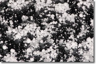
Weather Topic: What is Graupel?
Home - Education - Precipitation - Graupel
 Next Topic: Hail
Graupel is a form of precipitation that is created by atmospheric conditions
which cause supercooled water droplets to contact snow crystals and freeze to
their surface.
Sometimes known as soft hail or snow pellets, graupel is delicate and easily
destroyed by touch. Whereas hail usually falls during severe weather, graupel
doesn't require such conditions to form, and can form in mild precipitation
similar to situations which produce snowfall.
Next Topic: Hail
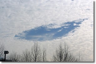
Weather Topic: What are Hole Punch Clouds?
Home - Education - Cloud Types - Hole Punch Clouds
 Next Topic: Mammatus Clouds
A hole punch cloud is an unusual occurrence when a disk-shaped
hole appears in a cirrostratus, cirrocumulus, or altocumulus cloud.
When part of the cloud forms ice crystals, water droplets in the surrounding area
of the cloud evaporate. The effect of this process produces a large elliptical
gap in the cloud. The hole punch cloud formation is rare, but it is not specific
to any geographic area.
Other names which have been used to describe this phenomena include fallstreak hole,
skypunch, and cloud hole.
Next Topic: Mammatus Clouds
Current conditions powered by WeatherAPI.com


