Weather Alert in Texas
High Wind Warning issued March 14 at 5:18AM CDT until March 14 at 8:00PM CDT by NWS Lubbock TX
AREAS AFFECTED: Parmer; Castro; Swisher; Bailey; Lamb; Hale; Cochran; Hockley; Lubbock; Yoakum; Terry; Lynn
DESCRIPTION: * WHAT...For the Blowing Dust Advisory, visibility between one-quarter and one mile in blowing dust. For the High Wind Warning, west winds 40 to 55 mph with gusts up to 80 mph expected. Isolated wind gusts to 90 mph will be possible across portions of the Caprock Escarpment. * WHERE...The South Plains and the far southwestern Texas Panhandle. * WHEN...Until 8 PM CDT this evening. * IMPACTS...High winds may move loose debris, damage property and cause power outages. Travel could be extremely difficult, especially for high profile vehicles and for those traveling on north-south oriented roads. Significant reductions in visibility from blowing dust are expected, with near-zero mile visibility possible. * ADDITIONAL DETAILS...Widespread blowing dust is expected which may result in significant visibility reductions and poor air quality.
INSTRUCTION: People are urged to secure loose objects that could be blown around or damaged by the wind. Travelers should be prepared to alter plans on Friday due to the potential for extremely difficult travel conditions.
Want more detail? Get the Complete 7 Day and Night Detailed Forecast!
Current U.S. National Radar--Current
The Current National Weather Radar is shown below with a UTC Time (subtract 5 hours from UTC to get Eastern Time).

National Weather Forecast--Current
The Current National Weather Forecast and National Weather Map are shown below.

National Weather Forecast for Tomorrow
Tomorrow National Weather Forecast and Tomorrow National Weather Map are show below.

North America Water Vapor (Moisture)
This map shows recent moisture content over North America. Bright and colored areas show high moisture (ie, clouds); brown indicates very little moisture present; black indicates no moisture.

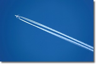
Weather Topic: What are Contrails?
Home - Education - Cloud Types - Contrails
 Next Topic: Cumulonimbus Clouds
A contrail is an artificial cloud, created by the passing of an
aircraft.
Contrails form because water vapor in the exhaust of aircraft engines is suspended
in the air under certain temperatures and humidity conditions. These contrails
are called exhaust contrails.
Another type of contrail can form due to a temporary reduction in air pressure
moving over the plane's surface, causing condensation.
These are called aerodynamic contrails.
When you can see your breath on a cold day, it is also because of condensation.
The reason contrails last longer than the condensation from your breath is
because the water in contrails freezes into ice particles.
Next Topic: Cumulonimbus Clouds
Weather Topic: What are Cumulus Clouds?
Home - Education - Cloud Types - Cumulus Clouds
 Next Topic: Drizzle
Cumulus clouds are fluffy and textured with rounded tops, and
may have flat bottoms. The border of a cumulus cloud
is clearly defined, and can have the appearance of cotton or cauliflower.
Cumulus clouds form at low altitudes (rarely above 2 km) but can grow very tall,
becoming cumulus congestus and possibly the even taller cumulonimbus clouds.
When cumulus clouds become taller, they have a greater chance of producing precipitation.
Next Topic: Drizzle


