Weather Alert in Texas
Blowing Dust Advisory issued March 14 at 5:18AM CDT until March 14 at 8:00PM CDT by NWS Lubbock TX
AREAS AFFECTED: Parmer; Castro; Swisher; Bailey; Lamb; Hale; Cochran; Hockley; Lubbock; Yoakum; Terry; Lynn
DESCRIPTION: * WHAT...For the Blowing Dust Advisory, visibility between one-quarter and one mile in blowing dust. For the High Wind Warning, west winds 40 to 55 mph with gusts up to 80 mph expected. Isolated wind gusts to 90 mph will be possible across portions of the Caprock Escarpment. * WHERE...The South Plains and the far southwestern Texas Panhandle. * WHEN...Until 8 PM CDT this evening. * IMPACTS...High winds may move loose debris, damage property and cause power outages. Travel could be extremely difficult, especially for high profile vehicles and for those traveling on north-south oriented roads. Significant reductions in visibility from blowing dust are expected, with near-zero mile visibility possible. * ADDITIONAL DETAILS...Widespread blowing dust is expected which may result in significant visibility reductions and poor air quality.
INSTRUCTION: People are urged to secure loose objects that could be blown around or damaged by the wind. Travelers should be prepared to alter plans on Friday due to the potential for extremely difficult travel conditions.
Want more detail? Get the Complete 7 Day and Night Detailed Forecast!
Current U.S. National Radar--Current
The Current National Weather Radar is shown below with a UTC Time (subtract 5 hours from UTC to get Eastern Time).

National Weather Forecast--Current
The Current National Weather Forecast and National Weather Map are shown below.

National Weather Forecast for Tomorrow
Tomorrow National Weather Forecast and Tomorrow National Weather Map are show below.

North America Water Vapor (Moisture)
This map shows recent moisture content over North America. Bright and colored areas show high moisture (ie, clouds); brown indicates very little moisture present; black indicates no moisture.

Weather Topic: What are Stratocumulus Clouds?
Home - Education - Cloud Types - Stratocumulus Clouds
 Next Topic: Stratus Clouds
Stratocumulus clouds are similar to altocumulus clouds in their
fluffy appearance, but have a slightly darker shade due to their additional mass.
A good way to distinguish the two cloud types is to hold your hand out and measure
the size of an individual cloud; if it is the size of your thumb it is generally
an altocumulus cloud, if it is the size of your hand it is generally a
stratocumulus cloud.
It is uncommon for stratocumulus clouds to produce precipitation, but if they do
it is usually a light rain or snow.
Next Topic: Stratus Clouds
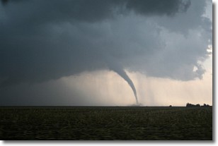
Weather Topic: What are Wall Clouds?
Home - Education - Cloud Types - Wall Clouds
 Next Topic: Altocumulus Clouds
A wall cloud forms underneath the base of a cumulonimbus cloud,
and can be a hotbed for deadly tornadoes.
Wall clouds are formed by air flowing into the cumulonimbus clouds, which can
result in the wall cloud descending from the base of the cumulonimbus cloud, or
rising fractus clouds which join to the base of the storm cloud as the wall cloud
takes shape.
Wall clouds can be very large, and in the Northern Hemisphere they generally
form at the southern edge of cumulonimbus clouds.
Next Topic: Altocumulus Clouds


