Weather Alert in Arkansas
Flood Warning issued April 23 at 9:26PM CDT until April 30 at 3:24AM CDT by NWS Memphis TN
AREAS AFFECTED: Lee, AR; Tunica, MS
DESCRIPTION: ...The Flood Warning continues for the following rivers in Arkansas...Mississippi...Tennessee...Missouri... Mississippi River at Helena Mississippi River at Memphis Mississippi River at Tunica Mhoon Landing Mississippi River Above Tiptonville Mississippi River at Caruthersville Mississippi River at Osceola For the Lower Mississippi River...including Tiptonville, Caruthersville, Osceola, Memphis, Tunica Mhoon Landing, Helena... Moderate flooding is forecast. * WHAT...Moderate flooding is occurring and moderate flooding is forecast. * WHERE...Mississippi River at Tunica Mhoon Landing. * WHEN...Until Wednesday, April 30. * IMPACTS...At 37.0 feet, Much of Bourbon Street is flooded. Grinner Drive is covered and the east end of Nel-Win Camp is going underwater. Lots along Tammy Road are being covered. Garden Lane is flooding and Carp Drive is being overtopped. * ADDITIONAL DETAILS... - At 8:00 PM CDT Wednesday the stage was 37.0 feet. - Recent Activity...The maximum river stage in the 24 hours ending at 8:00 PM CDT Wednesday was 37.4 feet. - Forecast...The river is expected to fall below flood stage early Tuesday morning and continue falling to 10.9 feet Wednesday, May 14. - Flood stage is 30.0 feet. - http://www.weather.gov/safety/flood
INSTRUCTION: Motorists should not attempt to drive around barricades or drive cars through flooded areas. Caution is urged when walking near riverbanks. Additional information is available at weather.gov/memphis. The next statement will be issued as needed.
Want more detail? Get the Complete 7 Day and Night Detailed Forecast!
Current U.S. National Radar--Current
The Current National Weather Radar is shown below with a UTC Time (subtract 5 hours from UTC to get Eastern Time).

National Weather Forecast--Current
The Current National Weather Forecast and National Weather Map are shown below.

National Weather Forecast for Tomorrow
Tomorrow National Weather Forecast and Tomorrow National Weather Map are show below.

North America Water Vapor (Moisture)
This map shows recent moisture content over North America. Bright and colored areas show high moisture (ie, clouds); brown indicates very little moisture present; black indicates no moisture.

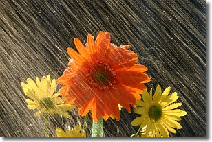
Weather Topic: What is Precipitation?
Home - Education - Precipitation - Precipitation
 Next Topic: Rain
Precipitation can refer to many different forms of water that
may fall from clouds. Precipitation occurs after a cloud has become saturated to
the point where its water particles are more dense than the air below the cloud.
In most cases, precipitation will reach the ground, but it is not uncommon for
precipitation to evaporate before it reaches the earth's surface.
When precipitation evaporates before it contacts the ground it is called Virga.
Graupel, hail, sleet, rain, drizzle, and snow are forms of precipitation, but fog
and mist are not considered precipitation because the water vapor which
constitutes them isn't dense enough to fall to the ground.
Next Topic: Rain
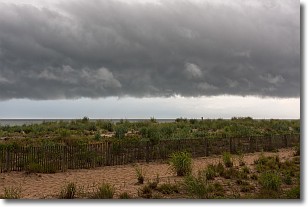
Weather Topic: What are Shelf Clouds?
Home - Education - Cloud Types - Shelf Clouds
 Next Topic: Sleet
A shelf cloud is similar to a wall cloud, but forms at the front
of a storm cloud, instead of at the rear, where wall clouds form.
A shelf cloud is caused by a series of events set into motion by the advancing
storm; first, cool air settles along the ground where precipitation has just fallen.
As the cool air is brought in, the warmer air is displaced, and rises above it,
because it is less dense. When the warmer air reaches the bottom of the storm cloud,
it begins to cool again, and the resulting condensation is a visible shelf cloud.
Next Topic: Sleet
Current conditions powered by WeatherAPI.com


