Weather Alert in Minnesota
Winter Storm Watch issued March 31 at 2:37AM CDT until April 3 at 1:00AM CDT by NWS Duluth MN
AREAS AFFECTED: Koochiching; North St. Louis; Northern Cook/Northern Lake; North Itasca; Central St. Louis; Southern Lake/North Shore; Southern Cook/North Shore; North Cass; South Itasca; South Cass; Crow Wing; Northern Aitkin; South Aitkin; Carlton/South St. Louis; Pine; Douglas; Bayfield
DESCRIPTION: * WHAT...Heavy snow possible. There is an 80 percent chance for at least 6 inches of snow accumulation. There is a 30 percent chance for at least 12 inches of snow or more along the North Shore and around the Brainerd Lakes. Winds could gust as high as 35 mph. * WHERE...In Minnesota, Crow Wing, Aitkin, Pine, Koochiching, Cass, Itasca, Carlton, St. Louis, Cook and Lake Counties. In Wisconsin, Bayfield and Douglas Counties. This includes the Tribal Lands of the Fond du Lac Band, the Red Cliff Band, the Grand Portage Reservation, the Mille Lacs Band, East Lake, Hinckley, Lena Lake and, Big Sandy Lake areas and the Bois Forte Band, Deer Creek, Lake Vermilion and, Nett Lake areas. Other locations including the Apostle Islands National Lakeshore and Voyageurs National Park. The entire Boundary Waters is also included. * WHEN...From Tuesday evening through late Wednesday night. * IMPACTS...Travel could be very difficult to impossible. The hazardous conditions could impact the Wednesday morning and evening commutes.
INSTRUCTION: Monitor the latest forecasts for updates on this situation.
Want more detail? Get the Complete 7 Day and Night Detailed Forecast!
Current U.S. National Radar--Current
The Current National Weather Radar is shown below with a UTC Time (subtract 5 hours from UTC to get Eastern Time).

National Weather Forecast--Current
The Current National Weather Forecast and National Weather Map are shown below.

National Weather Forecast for Tomorrow
Tomorrow National Weather Forecast and Tomorrow National Weather Map are show below.

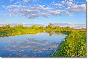
North America Water Vapor (Moisture)
This map shows recent moisture content over North America. Bright and colored areas show high moisture (ie, clouds); brown indicates very little moisture present; black indicates no moisture.

Weather Topic: What are Stratocumulus Clouds?
Home - Education - Cloud Types - Stratocumulus Clouds
 Next Topic: Stratus Clouds
Stratocumulus clouds are similar to altocumulus clouds in their
fluffy appearance, but have a slightly darker shade due to their additional mass.
A good way to distinguish the two cloud types is to hold your hand out and measure
the size of an individual cloud; if it is the size of your thumb it is generally
an altocumulus cloud, if it is the size of your hand it is generally a
stratocumulus cloud.
It is uncommon for stratocumulus clouds to produce precipitation, but if they do
it is usually a light rain or snow.
Next Topic: Stratus Clouds
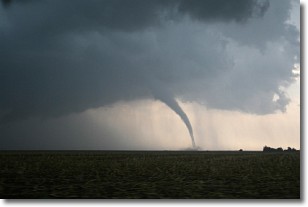
Weather Topic: What are Wall Clouds?
Home - Education - Cloud Types - Wall Clouds
 Next Topic: Altocumulus Clouds
A wall cloud forms underneath the base of a cumulonimbus cloud,
and can be a hotbed for deadly tornadoes.
Wall clouds are formed by air flowing into the cumulonimbus clouds, which can
result in the wall cloud descending from the base of the cumulonimbus cloud, or
rising fractus clouds which join to the base of the storm cloud as the wall cloud
takes shape.
Wall clouds can be very large, and in the Northern Hemisphere they generally
form at the southern edge of cumulonimbus clouds.
Next Topic: Altocumulus Clouds
Current conditions powered by WeatherAPI.com


