Weather Alert in Arkansas
Flood Warning issued March 13 at 11:03AM CDT until March 17 at 4:00AM CDT by NWS Little Rock AR
AREAS AFFECTED: White, AR; Woodruff, AR
DESCRIPTION: ...The Flood Warning is extended for the following rivers in Arkansas... White River At Augusta affecting White and Woodruff Counties. Cache River Near Patterson affecting Jackson and Woodruff Counties. For the Lower White River...including Newport, Augusta, Georgetown, Des Arc, Clarendon...Minor flooding is forecast. For the Cache River...including Patterson...Minor flooding is forecast. * WHAT...Minor flooding is occurring and minor flooding is forecast. * WHERE...White River at Augusta. * WHEN...Until early Monday morning. * IMPACTS...At 26.0 feet, Farm ground along the river in White and Woodruff counties begin to flood. Seasonal agricultural impacts. * ADDITIONAL DETAILS... - At 10:00 AM CDT Thursday the stage was 26.3 feet. - Forecast...The river is currently at 26.3 feet and is expected to fall below flood stage late Saturday evening. - Flood stage is 26.0 feet. - http://www.weather.gov/safety/flood
INSTRUCTION: Motorists should not attempt to drive around barricades or drive cars through flooded areas. River forecasts are based on current conditions and rainfall forecasted to occur over the next 24 hours. During periods of flooding...Evening forecasts are reissued with updated rainfall forecasts. Observed and forecasted stage data plots are available on our Advanced Hydrologic Prediction Service web page at... www.weather.gov/lzk Under the Current Conditions section...Select River and Lakes AHPS. The next statement will be issued Friday morning at 1115 AM CDT.
Want more detail? Get the Complete 7 Day and Night Detailed Forecast!
Current U.S. National Radar--Current
The Current National Weather Radar is shown below with a UTC Time (subtract 5 hours from UTC to get Eastern Time).

National Weather Forecast--Current
The Current National Weather Forecast and National Weather Map are shown below.

National Weather Forecast for Tomorrow
Tomorrow National Weather Forecast and Tomorrow National Weather Map are show below.

North America Water Vapor (Moisture)
This map shows recent moisture content over North America. Bright and colored areas show high moisture (ie, clouds); brown indicates very little moisture present; black indicates no moisture.

Weather Topic: What is Drizzle?
Home - Education - Precipitation - Drizzle
 Next Topic: Evaporation
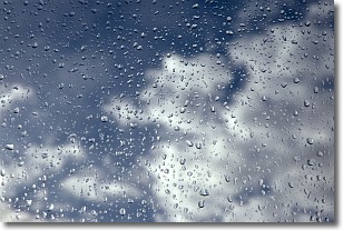
Drizzle is precipitation in the form of water droplets which are
smaller than raindrops.
Drizzle is characterized by fine, gently falling droplets and typically does not
impact human habitation in a negative way. The exception to this is freezing drizzle,
a condition where drizzle freezes immediately upon reaching earth's surface.
Freezing drizzle is still less dangerous than freezing rain, but can
potentially result in hazardous road conditions.
Next Topic: Evaporation
Weather Topic: What is Fog?
Home - Education - Cloud Types - Fog
 Next Topic: Fractus Clouds
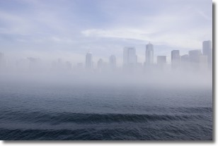
Fog is technically a type of stratus cloud, which lies along the
ground and obscures visibility.
It is usually created when humidity in the air condenses into tiny water droplets.
Because of this, some places are more prone to foggy weather, such as regions
close to a body of water.
Fog is similar to mist; both are the appearance of water droplets suspended in
the air, but fog is the term applied to the condition when visibility is less than 1 km.
Next Topic: Fractus Clouds


