Weather Alert in Arizona
Red Flag Warning issued March 31 at 1:25PM MST until April 1 at 8:00PM MST by NWS Tucson AZ
AREAS AFFECTED: Pima-South Central Pinal-Tohono Oodham Nation; Eastern Pima-Southeastern Pinal-Santa Cruz-Western Cochise; Southern Graham-Central and Eastern Cochise-Southern Greenlee-Lower Elevations of the San Carlos Apache Nation in Graham County
DESCRIPTION: * AFFECTED AREA...Fire Weather Zones 150, 151 and 152. * TIMING...From 1 PM to 8 PM MST Tuesday. * WINDS...West 25 to 35 mph with gusts up to 50 mph. * RELATIVE HUMIDITY...10 to 15 percent. * IMPACTS...Any fires that develop or are ongoing will have the potential to spread rapidly.
INSTRUCTION: A Red Flag Warning means that critical fire weather conditions are either occurring now...or are expected to develop. A combination of strong winds...low relative humidity...and dry vegetation will create the potential for rapid and erratic fire growth. Please advise the appropriate officials or fire crews in the field of the Red Flag Warning for portions of Southeast Arizona.
Want more detail? Get the Complete 7 Day and Night Detailed Forecast!
Current U.S. National Radar--Current
The Current National Weather Radar is shown below with a UTC Time (subtract 5 hours from UTC to get Eastern Time).

National Weather Forecast--Current
The Current National Weather Forecast and National Weather Map are shown below.

National Weather Forecast for Tomorrow
Tomorrow National Weather Forecast and Tomorrow National Weather Map are show below.

North America Water Vapor (Moisture)
This map shows recent moisture content over North America. Bright and colored areas show high moisture (ie, clouds); brown indicates very little moisture present; black indicates no moisture.

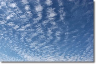
Weather Topic: What are Cirrocumulus Clouds?
Home - Education - Cloud Types - Cirrocumulus Clouds
 Next Topic: Cirrostratus Clouds
Cirrocumulus clouds form at high altitudes (usually around 5 km)
and have distinguishing characteristics displayed in a fine layer of
small cloud patches. These small cloud patches are sometimes referred to as
"cloudlets" in relation to the whole cloud formation.
Cirrocumulus clouds are formed from ice crystals and water droplets. Often, the
water droplets in the cloud freeze into ice crystals and the cloud becomes a
cirrostratus cloud. Because of this common occurrence, cirrocumulus cloud
formations generally pass rapidly.
Next Topic: Cirrostratus Clouds
Weather Topic: What are Cirrus Clouds?
Home - Education - Cloud Types - Cirrus Clouds
 Next Topic: Condensation
Cirrus clouds are high-level clouds that occur above 20,000 feet
and are composed mainly of ice crystals.
They are thin and wispy in appearance.
What do they indicate?
They are often the first sign of an approaching storm.
Next Topic: Condensation
Current conditions powered by WeatherAPI.com


