Weather Alert in Illinois
Special Weather Statement issued March 14 at 2:40AM CDT by NWS Lincoln IL
AREAS AFFECTED: Knox; Stark; Peoria; Marshall; Woodford; Fulton; Tazewell; McLean; Schuyler; Mason; Logan; De Witt; Piatt; Champaign; Vermilion; Cass; Menard; Scott; Morgan; Sangamon; Christian; Macon; Moultrie; Douglas; Coles; Edgar; Shelby; Cumberland; Clark; Effingham; Jasper; Crawford; Clay; Richland; Lawrence
DESCRIPTION: Warm and dry conditions are expected this afternoon, with minimum relative humidity values as low as 30 percent. These conditions, combined with dry fuels and southerly winds gusting 45-50 mph, will result in elevated fire danger this afternoon. Do not carelessly discard cigarettes or matches, use extra caution with farm machinery, and avoid open burning. The gusty winds could also cause blowing dust in areas where the soil has recently been disturbed. Don't enter any dust plumes if you can avoid it. If you encounter dense dust, slow down, pull off the roadway as far as possible, and set the emergency brake. Take your foot off the brake pedal to prevent traffic from following your tail lights.
INSTRUCTION: N/A
Want more detail? Get the Complete 7 Day and Night Detailed Forecast!
Current U.S. National Radar--Current
The Current National Weather Radar is shown below with a UTC Time (subtract 5 hours from UTC to get Eastern Time).

National Weather Forecast--Current
The Current National Weather Forecast and National Weather Map are shown below.

National Weather Forecast for Tomorrow
Tomorrow National Weather Forecast and Tomorrow National Weather Map are show below.

North America Water Vapor (Moisture)
This map shows recent moisture content over North America. Bright and colored areas show high moisture (ie, clouds); brown indicates very little moisture present; black indicates no moisture.

Weather Topic: What is Hail?
Home - Education - Precipitation - Hail
 Next Topic: Hole Punch Clouds
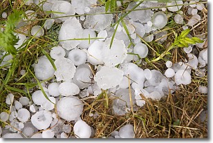
Hail is a form of precipitation which is recognized by large solid balls or
clumps of ice. Hail is created by thunderstorm clouds with strong updrafts of wind.
As the hailstones remain in the updraft, ice is deposited onto them until their
weight becomes heavy enough for them to fall to the earth's surface.
Hail storms can cause significant damage to crops, aircrafts, and man-made structures,
despite the fact that the duration is usually less than ten minutes.
Next Topic: Hole Punch Clouds
Weather Topic: What are Mammatus Clouds?
Home - Education - Cloud Types - Mammatus Clouds
 Next Topic: Nimbostratus Clouds
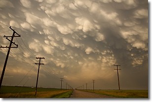
A mammatus cloud is a cloud with a unique feature which resembles
a web of pouches hanging along the base of the cloud.
In the United States, mammatus clouds tend to form in the warmer months, commonly
in the Midwest and eastern regions.
While they usually form at the bottom of a cumulonimbis cloud, they can also form
under altostratus, altocumulus, stratocumulus, and cirrus clouds. Mammatus clouds
warn that severe weather is close.
Next Topic: Nimbostratus Clouds


