Weather Alert in Arkansas
Flood Warning issued April 23 at 8:25PM CDT by NWS Little Rock AR
AREAS AFFECTED: Randolph, AR
DESCRIPTION: ...The Flood Warning continues for the following rivers in Arkansas... Black River At Pocahontas affecting Randolph County. Black River At Black Rock affecting Lawrence, Jackson and Independence Counties. For the Black River...including Corning, Pocahontas, Black Rock... Minor flooding is forecast. * WHAT...Minor flooding is occurring and minor flooding is forecast. * WHERE...Black River at Pocahontas. * WHEN...Until further notice. * IMPACTS...At 17.0 feet, Agricultural lands along the river east and south of Pocahontas will be impacted by high water. Equipment and livestock should be moved to higher ground. * ADDITIONAL DETAILS... - At 8:00 PM CDT Wednesday the stage was 17.4 feet. - Forecast...The river is expected to rise to a crest of 18.5 feet Friday morning. - Flood stage is 17.0 feet. - http://www.weather.gov/safety/flood
INSTRUCTION: Motorists should not attempt to drive around barricades or drive cars through flooded areas. Turn around, don't drown when encountering flooded roads. Most flood deaths occur in vehicles. River forecasts are based on current conditions and rainfall forecasted to occur over the next 24 hours. During periods of flooding...Evening forecasts are reissued with updated rainfall forecasts. Observed and forecasted stage data plots are available on our Advanced Hydrologic Prediction Service web page at... www.weather.gov/lzk Under the Current Conditions section...Select River and Lakes AHPS. The next statement will be issued Thursday evening at 830 PM CDT.
Want more detail? Get the Complete 7 Day and Night Detailed Forecast!
Current U.S. National Radar--Current
The Current National Weather Radar is shown below with a UTC Time (subtract 5 hours from UTC to get Eastern Time).

National Weather Forecast--Current
The Current National Weather Forecast and National Weather Map are shown below.

National Weather Forecast for Tomorrow
Tomorrow National Weather Forecast and Tomorrow National Weather Map are show below.

North America Water Vapor (Moisture)
This map shows recent moisture content over North America. Bright and colored areas show high moisture (ie, clouds); brown indicates very little moisture present; black indicates no moisture.

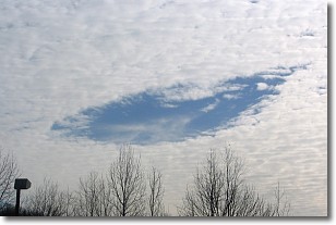
Weather Topic: What are Hole Punch Clouds?
Home - Education - Cloud Types - Hole Punch Clouds
 Next Topic: Mammatus Clouds
A hole punch cloud is an unusual occurrence when a disk-shaped
hole appears in a cirrostratus, cirrocumulus, or altocumulus cloud.
When part of the cloud forms ice crystals, water droplets in the surrounding area
of the cloud evaporate. The effect of this process produces a large elliptical
gap in the cloud. The hole punch cloud formation is rare, but it is not specific
to any geographic area.
Other names which have been used to describe this phenomena include fallstreak hole,
skypunch, and cloud hole.
Next Topic: Mammatus Clouds
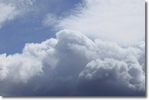
Weather Topic: What are Nimbostratus Clouds?
Home - Education - Cloud Types - Nimbostratus Clouds
 Next Topic: Precipitation
A nimbostratus cloud is similar to a stratus cloud in its formless,
smooth appearance. However, a nimbostratus cloud is darker than a stratus cloud,
because it is thicker.
Unlike a stratus cloud, a nimbostratus cloud typically brings with it the threat
of moderate to heavy precipitation. In some cases, the precipitation may evaporate
before reaching the ground, a phenomenon known as virga.
Next Topic: Precipitation
Current conditions powered by WeatherAPI.com


