Weather Alert in California
Winter Weather Advisory issued April 1 at 3:27AM PDT until April 1 at 5:00PM PDT by NWS Medford OR
AREAS AFFECTED: Modoc County; South Central Oregon Cascades; Siskiyou Mountains and Southern Oregon Cascades; Klamath Basin; Northern and Eastern Klamath County and Western Lake County; Central and Eastern Lake County
DESCRIPTION: * WHAT...Snow. Additional snow accumulations of up to 4 inches. * WHERE...The southern Oregon Cascades and Siskiyou Mountains. This includes Highways 230 and 138 near Diamond Lake, Highway 62 south of Crater Lake, and Highway 140. Additionally, areas around Mount Ashland are included. Portions of Klamath, Lake, and Modoc counties, including Lakeview, Chemult, Chiloquin, Valley Falls, Modoc Point, Davis Creek, the highway 97 corridor between Klamath Falls and Crescent, highway 140 east of Bly, highway 395 between Alturas and Alkali Lake, and highway 139 between Adin and Canby. * WHEN...Until 5 PM PDT this afternoon. * IMPACTS...Plan on slippery road conditions. * View the hazard area in detail at https://www.wrh.noaa.gov/map/?wfo=mfr
INSTRUCTION: * Slow down and allow extra time to reach your destination. * Carry tire chains and be prepared for snow covered roads and limited visibilities. * See https://www.tripcheck.com or https://quickmap.dot.ca.gov for latest road conditions. * A Winter Weather Advisory for snow means that periods of snow will cause travel difficulties.
Want more detail? Get the Complete 7 Day and Night Detailed Forecast!
Current U.S. National Radar--Current
The Current National Weather Radar is shown below with a UTC Time (subtract 5 hours from UTC to get Eastern Time).

National Weather Forecast--Current
The Current National Weather Forecast and National Weather Map are shown below.

National Weather Forecast for Tomorrow
Tomorrow National Weather Forecast and Tomorrow National Weather Map are show below.

North America Water Vapor (Moisture)
This map shows recent moisture content over North America. Bright and colored areas show high moisture (ie, clouds); brown indicates very little moisture present; black indicates no moisture.

Weather Topic: What are Fractus Clouds?
Home - Education - Cloud Types - Fractus Clouds
 Next Topic: Freezing Rain
A fractus cloud (scud) is a fragmented, tattered cloud which has
likely been sheared off of another cloud. They are accessory clouds, meaning they
develop from parent clouds, and are named in a way which describes the original
cloud which contained them.
Fractus clouds which have originated from cumulus clouds are referred to as
cumulus fractus, while fractus clouds which have originated from stratus clouds
are referred to as stratus fractus. Under certain conditions a fractus cloud might
merge with another cloud, or develop into a cumulus cloud, but usually a
fractus cloud seen by itself will dissipate rapidly.
They are often observed on the leading and trailing edges of storm clouds,
and are a display of wind activity.
Next Topic: Freezing Rain
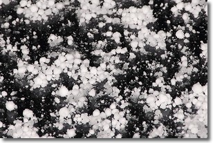
Weather Topic: What is Graupel?
Home - Education - Precipitation - Graupel
 Next Topic: Hail
Graupel is a form of precipitation that is created by atmospheric conditions
which cause supercooled water droplets to contact snow crystals and freeze to
their surface.
Sometimes known as soft hail or snow pellets, graupel is delicate and easily
destroyed by touch. Whereas hail usually falls during severe weather, graupel
doesn't require such conditions to form, and can form in mild precipitation
similar to situations which produce snowfall.
Next Topic: Hail
Current conditions powered by WeatherAPI.com


