Weather Alert in California
Winter Storm Warning issued April 1 at 3:27AM PDT until April 1 at 5:00PM PDT by NWS Medford OR
AREAS AFFECTED: Western Siskiyou County; North Central and Southeast Siskiyou County
DESCRIPTION: * WHAT...Heavy snow. Additional snow accumulations of 3 to 8 inches with up to a foot possible. Winds could gust as high as 35 mph. * WHERE...Portions of Siskiyou County above 3500 feet, including the Mount Shasta highlands, Medicine Lake, and the Klamath, Salmon, and Trinity mountains, as well as Etna Summit and Scott Mountain Summit. * WHEN...Until 5 PM PDT this afternoon. * IMPACTS...Travel could be very difficult to impossible. The hazardous conditions could impact the evening commute. * View the hazard area in detail at https://www.wrh.noaa.gov/map/?wfo=mfr
INSTRUCTION: * Travel is strongly discouraged because of dangerous conditions. Do not detour during winter storms. * If you must travel, keep tire chains, a flashlight, blankets, food, water, medications, and a fully charged phone with you. * The safest place during a winter storm is indoors. * A Winter Storm Warning means that severe winter weather is occurring and poses a threat to life and property. Take protective action now.
Want more detail? Get the Complete 7 Day and Night Detailed Forecast!
Current U.S. National Radar--Current
The Current National Weather Radar is shown below with a UTC Time (subtract 5 hours from UTC to get Eastern Time).

National Weather Forecast--Current
The Current National Weather Forecast and National Weather Map are shown below.

National Weather Forecast for Tomorrow
Tomorrow National Weather Forecast and Tomorrow National Weather Map are show below.

North America Water Vapor (Moisture)
This map shows recent moisture content over North America. Bright and colored areas show high moisture (ie, clouds); brown indicates very little moisture present; black indicates no moisture.

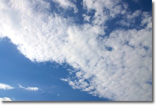
Weather Topic: What are Stratus Clouds?
Home - Education - Cloud Types - Stratus Clouds
 Next Topic: Wall Clouds
Stratus clouds are similar to altostratus clouds, but form at a
lower altitude and are identified by their fog-like appearance, lacking the
distinguishing features of most clouds.
Stratus clouds are wider than most clouds, and their base has a smooth, uniform
look which is lighter in color than a nimbostratus cloud.
The presence of a stratus cloud indicates the possibility of minor precipitation,
such as drizzle, but heavier precipitation does not typically arrive in the form
of a stratus cloud.
Next Topic: Wall Clouds
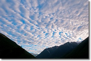
Weather Topic: What are Altocumulus Clouds?
Home - Education - Cloud Types - Altocumulus Clouds
 Next Topic: Altostratus Clouds
Similar to cirrocumulus clouds, altocumulus clouds are
characterized by cloud patches. They are distinguished by larger cloudlets
than cirrocumulus clouds but are still smaller than stratocumulus clouds.
Altocumulus clouds most commonly form in middle altitudes (between 2 and 5 km)
and may resemble, at times, the shape of a flying saucer.
These uncommon formations, called altocumulus lenticularis, are created by uplift
in the atmosphere and are most often seen in close proximity to mountains.
Next Topic: Altostratus Clouds
Current conditions powered by WeatherAPI.com


