Weather Alert in California
Winter Storm Warning issued April 1 at 3:27AM PDT until April 1 at 5:00PM PDT by NWS Medford OR
AREAS AFFECTED: South Central Siskiyou County
DESCRIPTION: * WHAT...For the Winter Storm Warning, heavy snow. Additional snow accumulations of 4 to 8 inches. For the Winter Weather Advisory, snow expected below 3500 feet. Additional snow accumulations of 3 to 5 inches. * WHERE...For the Winter Storm Warning, portions of Siskiyou County above 3500 feet, including the Mount Shasta highlands, Black Butte Summit along Interstate 5, and Snowman Summit and Dead Horse Summit along highway 89. For the Winter Weather Advisory, elevations at and below 3500 feet including portions of I-5, Mount Shasta City, Dunsmuir, and McCloud. * WHEN...Until 5 PM PDT this afternoon. * IMPACTS...Travel could be very difficult. The hazardous conditions could impact the evening commute. * View the hazard area in detail at https://www.wrh.noaa.gov/map/?wfo=mfr
INSTRUCTION: * Travel is strongly discouraged because of dangerous conditions. Do not detour during winter storms. * If you must travel, keep tire chains, a flashlight, blankets, food, water, medications, and a fully charged phone with you. * The safest place during a winter storm is indoors. * A Winter Storm Warning means that severe winter weather is occurring and poses a threat to life and property. Take protective action now.
Want more detail? Get the Complete 7 Day and Night Detailed Forecast!
Current U.S. National Radar--Current
The Current National Weather Radar is shown below with a UTC Time (subtract 5 hours from UTC to get Eastern Time).

National Weather Forecast--Current
The Current National Weather Forecast and National Weather Map are shown below.

National Weather Forecast for Tomorrow
Tomorrow National Weather Forecast and Tomorrow National Weather Map are show below.

North America Water Vapor (Moisture)
This map shows recent moisture content over North America. Bright and colored areas show high moisture (ie, clouds); brown indicates very little moisture present; black indicates no moisture.

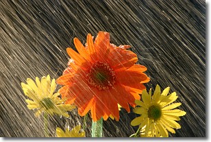
Weather Topic: What is Rain?
Home - Education - Precipitation - Rain
 Next Topic: Shelf Clouds
Precipitation in the form of water droplets is called rain.
Rain generally has a tendency to fall with less intensity over a greater period
of time, and when rainfall is more severe it is usually less sustained.
Rain is the most common form of precipitation and happens with greater frequency
depending on the season and regional influences. Cities have been shown to have
an observable effect on rainfall, due to an effect called the urban heat island.
Compared to upwind, monthly rainfall between twenty and forty miles downwind of
cities is 30% greater.
Next Topic: Shelf Clouds
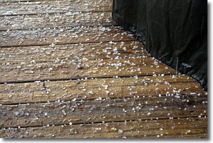
Weather Topic: What is Sleet?
Home - Education - Precipitation - Sleet
 Next Topic: Snow
Sleet is a form of precipitation in which small ice pellets are the primary
components. These ice pellets are smaller and more translucent than hailstones,
and harder than graupel. Sleet is caused by specific atmospheric conditions and
therefore typically doesn't last for extended periods of time.
The condition which leads to sleet formation requires a warmer body of air to be
wedged in between two sub-freezing bodies of air. When snow falls through a warmer
layer of air it melts, and as it falls through the next sub-freezing body of air
it freezes again, forming ice pellets known as sleet. In some cases, water
droplets don't have time to freeze before reaching the surface and the result is
freezing rain.
Next Topic: Snow
Current conditions powered by WeatherAPI.com


