Weather Alert in Iowa
Red Flag Warning issued March 14 at 2:31AM CDT until March 14 at 8:00PM CDT by NWS Quad Cities IA IL
AREAS AFFECTED: Buchanan; Delaware; Dubuque; Benton; Linn; Jones; Jackson; Iowa; Johnson; Cedar; Clinton; Muscatine; Scott; Keokuk; Washington; Louisa; Jefferson; Henry; Des Moines; Van Buren; Lee; Jo Daviess; Stephenson; Carroll; Whiteside; Rock Island; Henry; Bureau; Putnam; Mercer; Henderson; Warren; Hancock; McDonough; Scotland; Clark
DESCRIPTION: ...Critical Fire Weather Conditions... .The combination of strong southerly winds, low relative humidity, and dry fuels will result in critical fire weather conditions this afternoon and early evening before storms arrive. If a fire were to start, it would likely spread quickly and be difficult to extinguish. As a result, any outdoor burning is not recommended. The National Weather Service in Quad Cities has issued a Red Flag Warning for Critical Fire Weather Conditions, which is in effect from 1 PM this afternoon to 8 PM CDT this evening. The Fire Weather Watch is no longer in effect. * AFFECTED AREA...Jo Daviess, Stephenson, Carroll, Whiteside, Scotland, Clark, Rock Island, Henry IL, Bureau, Putnam, Mercer, Henderson, Warren, Hancock, McDonough, Buchanan, Delaware, Dubuque, Benton, Linn, Jones, Jackson, Iowa, Johnson, Cedar, Clinton, Muscatine, Scott, Keokuk, Washington, Louisa, Jefferson, Henry IA, Des Moines, Van Buren and Lee. * TIMING...From 1 PM this afternoon to 8 PM CDT this evening. * WINDS...Southeast 25 to 35 mph with gusts up to 50 mph. * RELATIVE HUMIDITY...As low as 30 percent. * TEMPERATURES...Upper 70s and lower 80s. * IMPACTS...Any fire that develops will catch and spread quickly. Outdoor burning is not recommended.
INSTRUCTION: A Red Flag Warning means that critical fire weather conditions are either occurring now, or will shortly. A combination of strong winds, low relative humidity, and warm temperatures can contribute to extreme fire behavior.
Want more detail? Get the Complete 7 Day and Night Detailed Forecast!
Current U.S. National Radar--Current
The Current National Weather Radar is shown below with a UTC Time (subtract 5 hours from UTC to get Eastern Time).

National Weather Forecast--Current
The Current National Weather Forecast and National Weather Map are shown below.

National Weather Forecast for Tomorrow
Tomorrow National Weather Forecast and Tomorrow National Weather Map are show below.

North America Water Vapor (Moisture)
This map shows recent moisture content over North America. Bright and colored areas show high moisture (ie, clouds); brown indicates very little moisture present; black indicates no moisture.

Weather Topic: What are Contrails?
Home - Education - Cloud Types - Contrails
 Next Topic: Cumulonimbus Clouds
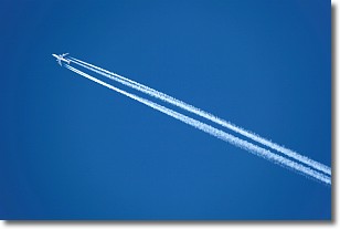
A contrail is an artificial cloud, created by the passing of an
aircraft.
Contrails form because water vapor in the exhaust of aircraft engines is suspended
in the air under certain temperatures and humidity conditions. These contrails
are called exhaust contrails.
Another type of contrail can form due to a temporary reduction in air pressure
moving over the plane's surface, causing condensation.
These are called aerodynamic contrails.
When you can see your breath on a cold day, it is also because of condensation.
The reason contrails last longer than the condensation from your breath is
because the water in contrails freezes into ice particles.
Next Topic: Cumulonimbus Clouds
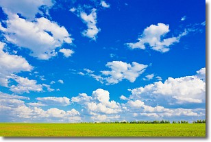
Weather Topic: What are Cumulus Clouds?
Home - Education - Cloud Types - Cumulus Clouds
 Next Topic: Drizzle
Cumulus clouds are fluffy and textured with rounded tops, and
may have flat bottoms. The border of a cumulus cloud
is clearly defined, and can have the appearance of cotton or cauliflower.
Cumulus clouds form at low altitudes (rarely above 2 km) but can grow very tall,
becoming cumulus congestus and possibly the even taller cumulonimbus clouds.
When cumulus clouds become taller, they have a greater chance of producing precipitation.
Next Topic: Drizzle


