Weather Alert in California
Winter Storm Warning issued March 13 at 2:13PM PDT until March 14 at 11:00PM PDT by NWS Sacramento CA
AREAS AFFECTED: West Slope Northern Sierra Nevada
DESCRIPTION: * WHAT...Periods of moderate to heavy snow expected through this evening with additional accumulations of 5 to 10 inches. The next system will bring heavy snow above 2000 feet on Friday. Total snow accumulations of 6 to 15 inches, with up to 2 feet over the peaks. Wind gusts as high as 65 mph. * WHERE...West Slope Northern Sierra Nevada. * WHEN...Until 11 PM PDT Friday. * IMPACTS...Travel could be very difficult to impossible at times. The hazardous conditions could impact the Thursday evening and Friday morning commutes. Strong winds could cause tree damage. * ADDITIONAL DETAILS...Heaviest snowfall expected Friday morning.
INSTRUCTION: Check the latest road conditions from Caltrans online at quickmap.dot.ca.gov or dial 5 1 1.
Want more detail? Get the Complete 7 Day and Night Detailed Forecast!
Current U.S. National Radar--Current
The Current National Weather Radar is shown below with a UTC Time (subtract 5 hours from UTC to get Eastern Time).

National Weather Forecast--Current
The Current National Weather Forecast and National Weather Map are shown below.

National Weather Forecast for Tomorrow
Tomorrow National Weather Forecast and Tomorrow National Weather Map are show below.

North America Water Vapor (Moisture)
This map shows recent moisture content over North America. Bright and colored areas show high moisture (ie, clouds); brown indicates very little moisture present; black indicates no moisture.

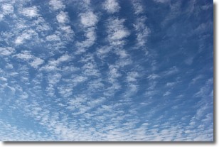
Weather Topic: What are Cirrocumulus Clouds?
Home - Education - Cloud Types - Cirrocumulus Clouds
 Next Topic: Cirrostratus Clouds
Cirrocumulus clouds form at high altitudes (usually around 5 km)
and have distinguishing characteristics displayed in a fine layer of
small cloud patches. These small cloud patches are sometimes referred to as
"cloudlets" in relation to the whole cloud formation.
Cirrocumulus clouds are formed from ice crystals and water droplets. Often, the
water droplets in the cloud freeze into ice crystals and the cloud becomes a
cirrostratus cloud. Because of this common occurrence, cirrocumulus cloud
formations generally pass rapidly.
Next Topic: Cirrostratus Clouds
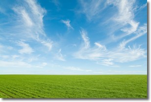
Weather Topic: What are Cirrus Clouds?
Home - Education - Cloud Types - Cirrus Clouds
 Next Topic: Condensation
Cirrus clouds are high-level clouds that occur above 20,000 feet
and are composed mainly of ice crystals.
They are thin and wispy in appearance.
What do they indicate?
They are often the first sign of an approaching storm.
Next Topic: Condensation


