Weather Alert in Oregon
Winter Storm Watch issued March 13 at 3:51AM PDT until March 15 at 5:00PM PDT by NWS Portland OR
AREAS AFFECTED: North Oregon Cascades; South Washington Cascades
DESCRIPTION: * WHAT...For the Winter Weather Advisory, snow. Additional snow accumulations up to 3 to 6 inches. For the Winter Storm Watch, heavy snow possible. Total snow accumulations up to 1 to 2 feet possible. Winds could gust as high as 35 mph. * WHERE...In Oregon, North Oregon Cascades. In Washington, South Washington Cascades. * WHEN...For the Winter Weather Advisory, until 11 PM PDT this evening. For the Winter Storm Watch, from late tonight through Saturday afternoon. * IMPACTS...Roads, and especially bridges and overpasses, will likely become slick and hazardous. Roads, and especially bridges and overpasses, will likely become slick and hazardous.
INSTRUCTION: Have a winter emergency driving kit readily available. Common items to include: flashlight, batteries, blankets, a shovel, water, non-perishable food items, tire chains, etc. Be aware that walking surfaces may be slick. Walk with extra care. For the latest road conditions and chain restrictions in Oregon, call 5 1 1, or visit: www.tripcheck.com. For the latest road conditions and chain restrictions in Washington, visit: wsdot.com/travel/real-time/map Winterize your vehicle and have a winter emergency driving kit readily available. Make sure your emergency kit has the following items: flashlights, batteries, blankets, a shovel, water, non-perishable food items, tire chains, etc. Now is a good time to put snow tires on your vehicle. Check on friends and family to see if they need help preparing. Monitor the latest forecasts and warnings for updates on this situation.
Want more detail? Get the Complete 7 Day and Night Detailed Forecast!
Current U.S. National Radar--Current
The Current National Weather Radar is shown below with a UTC Time (subtract 5 hours from UTC to get Eastern Time).

National Weather Forecast--Current
The Current National Weather Forecast and National Weather Map are shown below.

National Weather Forecast for Tomorrow
Tomorrow National Weather Forecast and Tomorrow National Weather Map are show below.

North America Water Vapor (Moisture)
This map shows recent moisture content over North America. Bright and colored areas show high moisture (ie, clouds); brown indicates very little moisture present; black indicates no moisture.

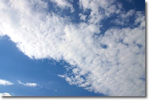
Weather Topic: What are Altocumulus Clouds?
Home - Education - Cloud Types - Altocumulus Clouds
 Next Topic: Altostratus Clouds
Similar to cirrocumulus clouds, altocumulus clouds are
characterized by cloud patches. They are distinguished by larger cloudlets
than cirrocumulus clouds but are still smaller than stratocumulus clouds.
Altocumulus clouds most commonly form in middle altitudes (between 2 and 5 km)
and may resemble, at times, the shape of a flying saucer.
These uncommon formations, called altocumulus lenticularis, are created by uplift
in the atmosphere and are most often seen in close proximity to mountains.
Next Topic: Altostratus Clouds
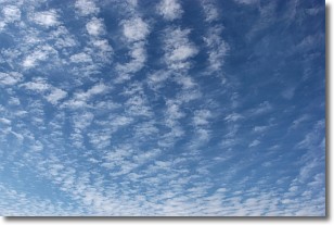
Weather Topic: What are Cirrocumulus Clouds?
Home - Education - Cloud Types - Cirrocumulus Clouds
 Next Topic: Cirrostratus Clouds
Cirrocumulus clouds form at high altitudes (usually around 5 km)
and have distinguishing characteristics displayed in a fine layer of
small cloud patches. These small cloud patches are sometimes referred to as
"cloudlets" in relation to the whole cloud formation.
Cirrocumulus clouds are formed from ice crystals and water droplets. Often, the
water droplets in the cloud freeze into ice crystals and the cloud becomes a
cirrostratus cloud. Because of this common occurrence, cirrocumulus cloud
formations generally pass rapidly.
Next Topic: Cirrostratus Clouds


