Weather Alert in Minnesota
Winter Storm Watch issued March 31 at 2:23AM CDT until April 2 at 7:00PM CDT by NWS Twin Cities/Chanhassen MN
AREAS AFFECTED: Douglas; Stevens; Pope; Swift; Kandiyohi
DESCRIPTION: ...SPRING STORM FORECAST TO BRING HEAVY SNOW TO PORTIONS OF WESTERN, CENTRAL MINNESOTA... .Another potent Spring Storm is on tap to arrive on Tuesday lasting into Wednesday with heavy snow expected for much of central Minnesota. The system will arrive in western Minnesota by Tuesday morning with a band of heavy snow expected to begin by the afternoon continuing overnight as the system pushes eastwards. Snow quality is expected to be on the heavier, slushier side as snow ratios favor below 10 to 1. An influx of mid level warm air could also lead to a wintry mix at times, with widespread rain to the south of the main band of snowfall. Snow will diminish by Wednesday afternoon as the system continues into the Great Lakes region. A broad area of 6 or more inches of snow is expected for parts of central Minnesota, with high end amounts potentially reaching the double digits. Ice accumulations should generally remain a glaze to a few hundredths at the most. * WHAT...Heavy mixed precipitation possible. Total snow accumulations between 6 and 12 inches and ice accumulations around a light glaze possible. Winds could gust as high as 35 mph. * WHERE...Kandiyohi, Douglas, Pope, Stevens, and Swift Counties. * WHEN...From Tuesday morning through Wednesday evening. * IMPACTS...Travel could be very difficult. The hazardous conditions could impact the Tuesday morning and evening commutes.
INSTRUCTION: Monitor the latest forecasts for updates on this situation.
Want more detail? Get the Complete 7 Day and Night Detailed Forecast!
Current U.S. National Radar--Current
The Current National Weather Radar is shown below with a UTC Time (subtract 5 hours from UTC to get Eastern Time).

National Weather Forecast--Current
The Current National Weather Forecast and National Weather Map are shown below.

National Weather Forecast for Tomorrow
Tomorrow National Weather Forecast and Tomorrow National Weather Map are show below.

North America Water Vapor (Moisture)
This map shows recent moisture content over North America. Bright and colored areas show high moisture (ie, clouds); brown indicates very little moisture present; black indicates no moisture.

Weather Topic: What are Stratus Clouds?
Home - Education - Cloud Types - Stratus Clouds
 Next Topic: Wall Clouds
Stratus clouds are similar to altostratus clouds, but form at a
lower altitude and are identified by their fog-like appearance, lacking the
distinguishing features of most clouds.
Stratus clouds are wider than most clouds, and their base has a smooth, uniform
look which is lighter in color than a nimbostratus cloud.
The presence of a stratus cloud indicates the possibility of minor precipitation,
such as drizzle, but heavier precipitation does not typically arrive in the form
of a stratus cloud.
Next Topic: Wall Clouds
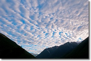
Weather Topic: What are Altocumulus Clouds?
Home - Education - Cloud Types - Altocumulus Clouds
 Next Topic: Altostratus Clouds
Similar to cirrocumulus clouds, altocumulus clouds are
characterized by cloud patches. They are distinguished by larger cloudlets
than cirrocumulus clouds but are still smaller than stratocumulus clouds.
Altocumulus clouds most commonly form in middle altitudes (between 2 and 5 km)
and may resemble, at times, the shape of a flying saucer.
These uncommon formations, called altocumulus lenticularis, are created by uplift
in the atmosphere and are most often seen in close proximity to mountains.
Next Topic: Altostratus Clouds
Current conditions powered by WeatherAPI.com


