Weather Alert in Colorado
High Wind Watch issued March 31 at 10:36AM MDT until April 1 at 7:00PM MDT by NWS Pueblo CO
AREAS AFFECTED: Del Norte Vicinity/Northern San Luis Valley Below 8500 Ft; Alamosa Vicinity/Central San Luis Valley Below 8500 Ft; Southern San Luis Valley; Pueblo Vicinity/Pueblo County Below 6300 Feet; Walsenburg Vicinity/Upper Huerfano River Basin Below 7500 Ft; Trinidad Vicinity/Western Las Animas County Below 7500 Ft; La Junta Vicinity/Otero County; Eastern Las Animas County; Las Animas Vicinity/Bent County; Lamar Vicinity/Prowers County; Springfield Vicinity/Baca County
DESCRIPTION: * WHAT...Southwest winds 30 to 40 mph with gusts up to 65 mph possible. The strongest gusts will be across the San Luis Valley and the southern I-25 corridor and adjacent plains south of highway 50. * WHERE...The San Luis Valley, Pueblo, Huerfano, Las Animas, Bent, Prowers and Baca Counties. * WHEN...From Tuesday morning through Tuesday evening. * IMPACTS...Damaging winds could blow down trees and power lines. Power outages are possible. Travel could be difficult, especially for high profile vehicles on north south oriented roadways. * ADDITIONAL DETAILS...Areas of blowing dust could cause significant visibility restrictions at times.
INSTRUCTION: Monitor the latest forecasts and warnings for updates.
Want more detail? Get the Complete 7 Day and Night Detailed Forecast!
Current U.S. National Radar--Current
The Current National Weather Radar is shown below with a UTC Time (subtract 5 hours from UTC to get Eastern Time).

National Weather Forecast--Current
The Current National Weather Forecast and National Weather Map are shown below.

National Weather Forecast for Tomorrow
Tomorrow National Weather Forecast and Tomorrow National Weather Map are show below.

North America Water Vapor (Moisture)
This map shows recent moisture content over North America. Bright and colored areas show high moisture (ie, clouds); brown indicates very little moisture present; black indicates no moisture.

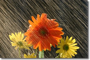
Weather Topic: What is Rain?
Home - Education - Precipitation - Rain
 Next Topic: Shelf Clouds
Precipitation in the form of water droplets is called rain.
Rain generally has a tendency to fall with less intensity over a greater period
of time, and when rainfall is more severe it is usually less sustained.
Rain is the most common form of precipitation and happens with greater frequency
depending on the season and regional influences. Cities have been shown to have
an observable effect on rainfall, due to an effect called the urban heat island.
Compared to upwind, monthly rainfall between twenty and forty miles downwind of
cities is 30% greater.
Next Topic: Shelf Clouds
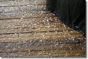
Weather Topic: What is Sleet?
Home - Education - Precipitation - Sleet
 Next Topic: Snow
Sleet is a form of precipitation in which small ice pellets are the primary
components. These ice pellets are smaller and more translucent than hailstones,
and harder than graupel. Sleet is caused by specific atmospheric conditions and
therefore typically doesn't last for extended periods of time.
The condition which leads to sleet formation requires a warmer body of air to be
wedged in between two sub-freezing bodies of air. When snow falls through a warmer
layer of air it melts, and as it falls through the next sub-freezing body of air
it freezes again, forming ice pellets known as sleet. In some cases, water
droplets don't have time to freeze before reaching the surface and the result is
freezing rain.
Next Topic: Snow
Current conditions powered by WeatherAPI.com


