Weather Alert in California
Winter Storm Warning issued March 30 at 1:57PM PDT until March 31 at 11:00PM PDT by NWS Reno NV
AREAS AFFECTED: Greater Lake Tahoe Area; Greater Lake Tahoe Area
DESCRIPTION: * WHAT...For the Winter Storm Warning, heavy snow. Snow accumulations between 1 to 2 feet above 6500 feet with snow accumulations between 6 to 12 inches below 6500 feet. Locally higher snowfall amounts up to 3 feet possible at the highest elevations. Ridge winds gusting as high as 100 mph. Lake Tahoe winds gusting up to 40 mph with waves of 2 to 3 feet. For the Winter Weather Advisory, snow. Snow accumulations between 4 and 11 inches below 6500 feet. Locally higher amounts up to 15 inches in the highest elevations. Winds gusting as high as 45 mph. * WHERE...Greater Lake Tahoe Area. * WHEN...For the Winter Storm Warning, from 5 PM this afternoon to 11 PM PDT Monday. For the Winter Weather Advisory, from 5 AM to 11 PM PDT Tuesday. * IMPACTS...Travel could be very difficult to impossible. The hazardous conditions could impact the Monday morning and evening commutes. Strong winds could cause damage to trees and power lines.
INSTRUCTION: Slow down and use caution while traveling. The latest road conditions for the state you are calling from can be obtained by calling 5 1 1. If you must travel, keep an extra flashlight, food, and water in your vehicle in case of an emergency. The latest road conditions for the state you are calling from can be obtained by calling 5 1 1.
Want more detail? Get the Complete 7 Day and Night Detailed Forecast!
Current U.S. National Radar--Current
The Current National Weather Radar is shown below with a UTC Time (subtract 5 hours from UTC to get Eastern Time).

National Weather Forecast--Current
The Current National Weather Forecast and National Weather Map are shown below.

National Weather Forecast for Tomorrow
Tomorrow National Weather Forecast and Tomorrow National Weather Map are show below.

North America Water Vapor (Moisture)
This map shows recent moisture content over North America. Bright and colored areas show high moisture (ie, clouds); brown indicates very little moisture present; black indicates no moisture.

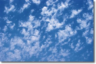
Weather Topic: What are Fractus Clouds?
Home - Education - Cloud Types - Fractus Clouds
 Next Topic: Freezing Rain
A fractus cloud (scud) is a fragmented, tattered cloud which has
likely been sheared off of another cloud. They are accessory clouds, meaning they
develop from parent clouds, and are named in a way which describes the original
cloud which contained them.
Fractus clouds which have originated from cumulus clouds are referred to as
cumulus fractus, while fractus clouds which have originated from stratus clouds
are referred to as stratus fractus. Under certain conditions a fractus cloud might
merge with another cloud, or develop into a cumulus cloud, but usually a
fractus cloud seen by itself will dissipate rapidly.
They are often observed on the leading and trailing edges of storm clouds,
and are a display of wind activity.
Next Topic: Freezing Rain
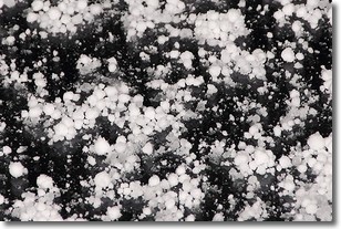
Weather Topic: What is Graupel?
Home - Education - Precipitation - Graupel
 Next Topic: Hail
Graupel is a form of precipitation that is created by atmospheric conditions
which cause supercooled water droplets to contact snow crystals and freeze to
their surface.
Sometimes known as soft hail or snow pellets, graupel is delicate and easily
destroyed by touch. Whereas hail usually falls during severe weather, graupel
doesn't require such conditions to form, and can form in mild precipitation
similar to situations which produce snowfall.
Next Topic: Hail
Current conditions powered by WeatherAPI.com


