Weather Alert in Texas
Fire Weather Watch issued March 14 at 6:50AM CDT until March 15 at 9:00PM CDT by NWS Fort Worth TX
AREAS AFFECTED: Lampasas; Coryell; Bell; McLennan; Falls; Limestone; Leon; Milam; Robertson
DESCRIPTION: ...DANGEROUS FIRE WEATHER CONDITIONS EXPECTED TODAY... * AFFECTED AREA...Central Texas. * TIMING...Late Friday morning through Saturday evening. * WINDS...West 15 to 25 mph with gusts up to 45 mph. * RELATIVE HUMIDITY...As low as 15 percent. * TEMPERATURES...80 to 87 degrees. * IMPACTS...Rapid spread of wildfires is possible due to very strong southwesterly winds and low relative humidity values.
INSTRUCTION: A Red Flag Warning means that extreme fire weather conditions are either occurring now, or will shortly. A combination of strong winds, low relative humidity, and dry vegetation can contribute to extreme fire behavior. Avoid all outside burning and welding today. Do not toss lit cigarette butts outside. Report wild fires to the nearest fire department or law enforcement office. A Fire Weather Watch means that critical fire weather conditions are forecast to occur. Listen for later forecasts and possible Red Flag Warnings.
Want more detail? Get the Complete 7 Day and Night Detailed Forecast!
Current U.S. National Radar--Current
The Current National Weather Radar is shown below with a UTC Time (subtract 5 hours from UTC to get Eastern Time).

National Weather Forecast--Current
The Current National Weather Forecast and National Weather Map are shown below.

National Weather Forecast for Tomorrow
Tomorrow National Weather Forecast and Tomorrow National Weather Map are show below.

North America Water Vapor (Moisture)
This map shows recent moisture content over North America. Bright and colored areas show high moisture (ie, clouds); brown indicates very little moisture present; black indicates no moisture.

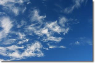
Weather Topic: What are Cirrostratus Clouds?
Home - Education - Cloud Types - Cirrostratus Clouds
 Next Topic: Cirrus Clouds
Cirrostratus clouds are high, thin clouds that form above
20,000 feet and are made mostly of ice crystals. They sometimes look like giant
feathers, horse tails, or curls of hair in the sky.
These clouds are pushed by the jet stream and can move at high speeds reaching
100 mph.
What do they indicate?
They indicate that a precipitation is likely within 24 hours.
Next Topic: Cirrus Clouds
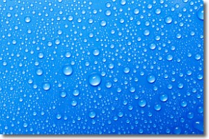
Weather Topic: What is Condensation?
Home - Education - Precipitation - Condensation
 Next Topic: Contrails
Condensation is the process which creates clouds, and therefore
it is a crucial process in the water cycle.
Condensation is the change of matter from a state of gas into a state of liquid,
and it happens because water molecules release heat into the atmosphere and
become organized into a more closely packed structure, what we might see as
water droplets.
Water is always present in the air around us as a vapor, but it's too small for
us to see. When water undergoes the process of condensation it becomes organized
into visible water droplets. You've probably seen condensation happen before on the
surface of a cold drink!
Next Topic: Contrails


