Weather Alert in Arizona
Wind Advisory issued March 31 at 2:00AM MST until April 1 at 8:00PM MST by NWS Tucson AZ
AREAS AFFECTED: Upper San Pedro River Valley including Sierra Vista/Benson; Eastern Cochise County Below 5000 Feet including Douglas/Willcox; Upper Gila River and Aravaipa Valleys including Clifton/Safford; White Mountains of Graham and Greenlee Counties including Hannagan Meadow; Galiuro and Pinaleno Mountains including Mount Graham; Chiricahua Mountains including Chiricahua National Monument; Dragoon/Mule/Huachuca and Santa Rita Mountains including Bisbee/Canelo Hills/Madera Canyon
DESCRIPTION: * WHAT...West winds 25 to 30 mph with gusts 45-50 mph. These winds will produce areas of blowing dust reducing visibility at times, especially in dust-prone areas near and west of the Willcox Playa in Cochise county, as well as southeast Graham county and southern Greenlee county. * WHERE...Cochise, Graham, Greenlee and the far eastern portions of Santa Cruz counties. * WHEN...From 11 AM to 8 PM MST Tuesday. * IMPACTS...Strong winds may make driving difficult for high-profile vehicles. Gusty winds will blow around unsecured objects. Tree limbs could be blown down. Blowing dust may reduce visibility at times.
INSTRUCTION: Winds this strong can make driving difficult, especially for high profile vehicles. Use extra caution. Secure outdoor objects.
Want more detail? Get the Complete 7 Day and Night Detailed Forecast!
Current U.S. National Radar--Current
The Current National Weather Radar is shown below with a UTC Time (subtract 5 hours from UTC to get Eastern Time).

National Weather Forecast--Current
The Current National Weather Forecast and National Weather Map are shown below.

National Weather Forecast for Tomorrow
Tomorrow National Weather Forecast and Tomorrow National Weather Map are show below.

North America Water Vapor (Moisture)
This map shows recent moisture content over North America. Bright and colored areas show high moisture (ie, clouds); brown indicates very little moisture present; black indicates no moisture.

Weather Topic: What are Hole Punch Clouds?
Home - Education - Cloud Types - Hole Punch Clouds
 Next Topic: Mammatus Clouds
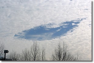
A hole punch cloud is an unusual occurrence when a disk-shaped
hole appears in a cirrostratus, cirrocumulus, or altocumulus cloud.
When part of the cloud forms ice crystals, water droplets in the surrounding area
of the cloud evaporate. The effect of this process produces a large elliptical
gap in the cloud. The hole punch cloud formation is rare, but it is not specific
to any geographic area.
Other names which have been used to describe this phenomena include fallstreak hole,
skypunch, and cloud hole.
Next Topic: Mammatus Clouds
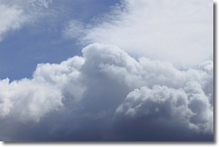
Weather Topic: What are Nimbostratus Clouds?
Home - Education - Cloud Types - Nimbostratus Clouds
 Next Topic: Precipitation
A nimbostratus cloud is similar to a stratus cloud in its formless,
smooth appearance. However, a nimbostratus cloud is darker than a stratus cloud,
because it is thicker.
Unlike a stratus cloud, a nimbostratus cloud typically brings with it the threat
of moderate to heavy precipitation. In some cases, the precipitation may evaporate
before reaching the ground, a phenomenon known as virga.
Next Topic: Precipitation
Current conditions powered by WeatherAPI.com


